

Traffic impacts
We have developed a traffic model to show what effects our proposals would be expected to have on traffic levels and journey times. This allows us to predict what travel impact the proposed changes could have on road users and bus passengers for the busiest times of the day, with results presented for the morning (08:30 to 09:30) and evening (18:00 to 19:00).
A traffic model is a representation of real-world conditions, developed to replicate traffic operation at a defined point in time. It is built using actual traffic data and tested to ensure that it reflects the road network as much as possible. The model can then be adapted to test the operational impacts of proposed changes, with any assumptions based on available evidence and recorded for transparency.
Modelling provides a simulated environment in which proposals can be assessed without the cost or disruption of real-world trials, and potential impacts on traffic flow, journey time and network capacity to be understood.
Traffic models are developed with care to ensure that any simplifications remain appropriate and do not detract from their overall usefulness. These considerations will be considered when interpreting the results, helping to provide a clear and well-supported understanding of the likely impacts.
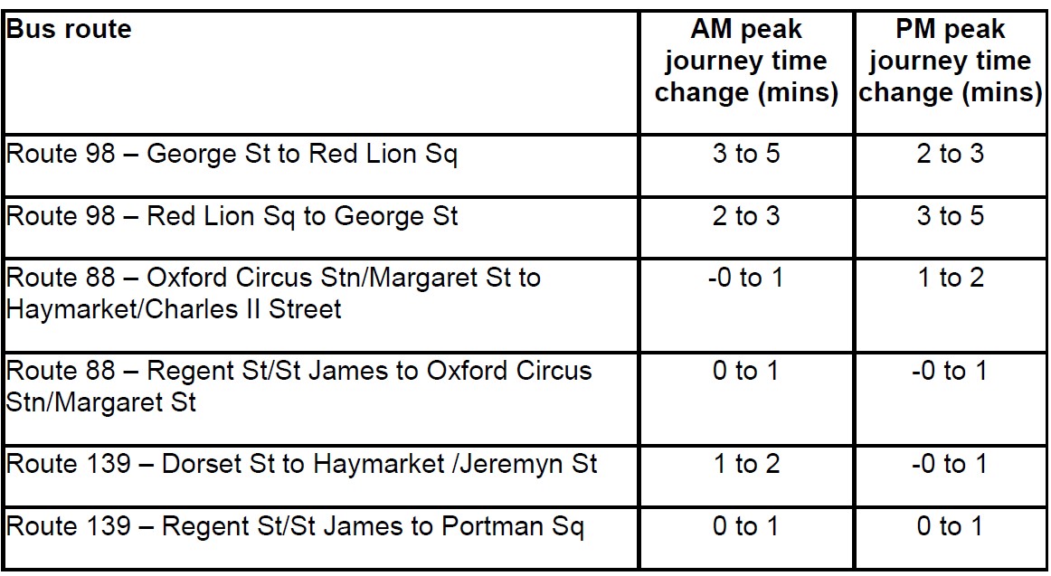
How will my bus journey change because of the proposed pedestrianisation?
Due to the changes to the network which could result from the pedestrianisation of Oxford Street West in accordance with our proposals, some bus routes, such as route 98, that currently travel along Oxford Street, would operate on Wigmore Street and Henrietta Place between Orchard Street and Great Portland Street.
The changes we have proposed mean that people travelling on bus route 98 eastbound are forecasted to experience a longer journey time of 2 to 3 minutes during the evening peak, and a longer journey time of 3 to 5 minutes during the morning peak, if the proposals are implemented.
For the route 98 westbound during the evening peaks, journey times would be expected to increase by 3 to 5 minutes.
On other bus routes, like routes 88 which operates along Regent Street, bus passengers would be expected to have a similar experience with a reduction of up to 1 minute when travelling northbound during the evening peak. During the same peak, southbound bus passenger can expect an increase of 1 to 2 minutes as a result of the Oxford Street pedestrianisation proposal.
The table below shows journey time changes for all those bus routes that would be affected by the proposed pedestrianisation of Oxford Street West. Bus routes not included in this table would not be affected by our proposals.
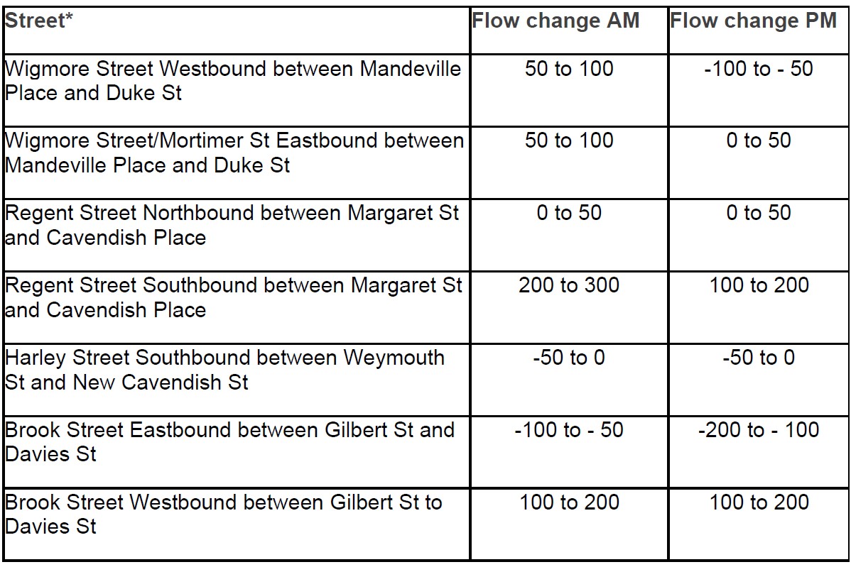
How will traffic flows change in the local area?
Pedestrianisation and the associated road network changes would be expected to result in individuals choosing different routes to complete their journeys: we call this ‘redistribution’. It is expected that buses, taxis and cycles currently using Oxford Street would, if our proposals were implemented, use a range of nearby adjacent routes.
As a result, we forecast that there would be an increase of 0 to 50 vehicles using Wigmore Street between Mandeville Road and Duke Street in the eastbound direction during the evening peak and Wigmore St westbound during the PM peak would be expected to see a decrease of -100 to -50 vehicles.
Other alternative routes such as Brook Street eastbound would see a decrease of -200 to -100 vehicles in the evening peak and Harley Street Southbound would see a change of -50 to 0 vehicle in the evening peak.
The table below shows selected traffic flow changes: we have selected the streets included in the table because we consider that these are the key routes which are likely to see a change in traffic flows. Additional information on traffic flow changes within the modelling study area is available here.
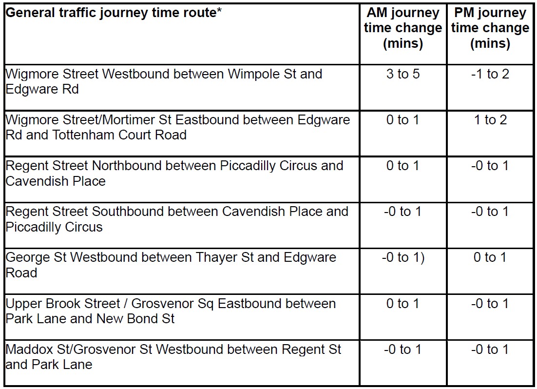
What will be the journey time changes for other traffic?
Due to the forecasted redistribution of traffic and road network alterations, journey times for traffic other than buses are also expected to change if our proposals are implemented. For example, an eastbound journey on Wigmore Street and Mortimer St between Edgware Road and Tottenham Court Road would increase by 1 to 2 minutes in the evening peak. Westbound journeys on Wigmore Street between Wimpole St and Edgware Rd during the evening peak are expected to have a 1 to 2 minutes decrease in journey times. We anticipate some journey times will remain the same or reduce.
Our traffic model does not differentiate between taxis, cars and freight vehicles, so it is not possible for us to provide information about what specific journey time changes there might be for taxis or private hire vehicles.
We propose that taxis would no longer have access to Oxford Street West (private hire vehicles are already restricted from using Oxford Street), and would instead use Wigmore Street, or other surrounding streets to access the area or travel around it. We have described in the following section what journey time changes there would be for general traffic in the area surrounding Oxford Street West.
The table below shows selected general traffic journey time changes along streets in the vicinity of Oxford Street. We have selected the streets included in the table because we consider that these are the key routes which are likely to see a change in traffic flows. Additional information on journey time changes for other traffic using additional roads is available here.
Consultation has concluded

