Syon Park to Hounslow town centre walking and cycling improvements
We are proposing to extend the western section of Cycleway 9 between Syon Park and Hounslow Town centre, upgrade pedestrian crossings along the route, make side roads safer to cross, widen footways and explore opportunities for more planting and trees.
By clicking on each of the buttons below, you can read more about what is proposed and how this may impact you. You can also view maps, ask questions, read frequently asked questions (FAQs), provide feedback, and find out about other ways to get in touch and take part.
You have until Monday 19 October 2026 to give us your feedback.
Proposals
We first consulted on proposals for the Brentford to Hounslow town centre Cycleway 9 route in 2022. Since then, the design has been refined in response to feedback received. We are now consulting on the remaining sections of the route between Syon Park and Hounslow town centre.Please watch the video below to see an overview of the changes we are proposing.
The proposals cover sections of London Road and High Street (the A315) between Syon Park and Hounslow town centre.
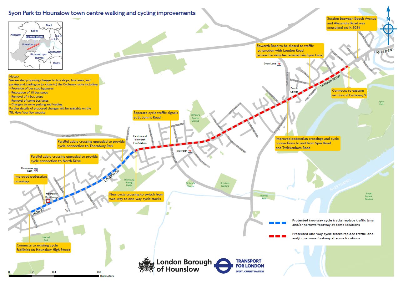 Click on image for larger version
We have organised the proposals into sections along the A315 so it is easier to understand what is proposed where. You can find detailed maps of all the proposals by clicking the ‘More information’ button.
Beech Avenue to Busch Corner
- Provide a new segregated cycle track on either side of London Road, connecting with the section of the Brentford to Hounslow route previously consulted on east of Beech Avenue
- Remove the eastbound Beech Avenue bus stop and relocate services to bus stop X, approximately 160 metres west of the existing stop
- Introduce a new bus stop bypass with pedestrian crossings at bus stops Syon Lane X and W, allowing cyclists to pass behind waiting passengers while maintaining safe access to buses
- Relocate and widen the pedestrian island near Syon Lane
- Close the junction of Epworth Road and London Road to motor traffic, with access to Epworth Road maintained via Syon Lane. To accommodate the new cycle track, the pedestrian island near Epworth Road would also be removed
You can view a map of the proposals here.
Busch Corner Junction
- Introduce protected cycle facilities through the junction, supported by dedicated cycle signals
- Widen pedestrian crossings on all arms of the junction and retain signal control
- Provide an Advanced Stop Line for cyclists on the northern approach to improve visibility and positioning
- Enlarge traffic islands to provide more space for pedestrians
- Remove the north-west left-turn slip road and create a shared pedestrian and cycle route between London Road and Spur Road, making it easier for cyclists travelling westbound on London Road to access Spur Road. Left-turn access for vehicles would be retained via the junction
- Introduce bus stop bypasses with pedestrian crossings at bus stops Busch Corner V, T and P
- Refresh road markings and replace highway assets where needed
You can view a map of the proposals here.
Busch Corner to Langley Road
- Provide a continuous segregated cycle track between Busch Corner and Langley Road
- Introduce ‘side-road entry improvements’ at side street junctions to slow turning vehicles and improve safety for pedestrians and cyclists. These raise the level of the carriageway at the junction to provide a flat, level surface for pedestrians to cross. It also has the effect of forcing traffic to slow down when entering the side road
- Install bus stop bypasses with pedestrian crossings at bus stops S, R, M, D and Q
- Widen the zebra crossing near Darcy Road to improve pedestrian access
- Widen the pedestrian island near Hartham Road to provide more space for people crossing
- Remove the traffic island at the Amhurst Gardens junction to accommodate the new cycle track
- To help maintain access for deliveries and servicing, new loading bays are proposed on Hartham Road and the service road near Teesdale Avenue
You can view a map of the proposals here.
Langley Road to Avenue Road
- Continue the segregated cycle track through this section of London Road
- Introduce ‘side-road entry improvements’ at junctions along this section, including Primrose Place and Langley Road, to slow turning vehicles and improve safety for pedestrians and cyclists
- Introduce bus stop bypasses at stops E, F and N
- Remove bus stop P (Linkfield Road) to accommodate the new cycle track. Bus services would continue to be available from the nearest bus stop Q (located approximately 122 metres east from the existing stop)
- Remove three parking bays outside 434-450 London Road on the north side of the road to accommodate the eastbound cycle track and provide one additional parking bay on the south side of the road near Isleworth Station, as shown on the map
- Remove the traffic island opposite Linkfield Road to create more space for the cycle track and improve movement along this section of London Road
- Improve crossings at side roads along the route, including Linkfield Road, College Road and Avenue Road, through raised crossings and upgrading pedestrian waiting areas
You can view a map of the proposals here.
St John's Road to Spring Grove
- Improve pedestrian crossings outside Sainsbury’s Local (489 London Road) by introducing signal-controlled crossings, removing the existing traffic island and enlarging the pedestrian island to provide more space for people waiting to cross
- Extend the eastbound ahead and right-turn lanes between The Grove and St John's Road to improve traffic flow. An Advanced Stop Line would also be provided at the St John's Road junction, helping cyclists position themselves more visibly at traffic signals
- To accommodate the westbound cycle track, five parking spaces outside 490-495 London Road would be removed. Parking on the north side (outside of 484 London Road) would be increased from eight to ten spaces
- Narrow the vehicle access points to the garage west of St John's Road, reducing the distance pedestrians need to cross
- Introduce a bus stop bypass at bus stop L with a pedestrian crossing outside West Thames College to provide safe access to bus services
- Introduce a bus stop bypass at bus stop G
- Continue the cycle route beyond Sidmouth Avenue by introducing a segregated two-way cycle track on one side of London Road. A new signal-controlled crossing would enable cyclists to safely transition between the one-way cycle tracks in the previous section and the new two-way facility
You can view a map of the proposals here.
Spring Grove to Honnor Gardens
- Relocate bus stop K outside the parade of shops (532-572 London Road) and move the parking and loading bays here closer to the Spring Grove junction. This would also allow us to increase the number of parking spaces from 10 to 13 while retaining one loading bay. To accommodate the cycle track, 6 parking spaces outside Warren Motors on the south side of London Road would be removed
- Install a new ‘parallel’ crossing west of Thornbury Road, providing a safer crossing for pedestrians and cyclists and improving access to Thornbury Park. A ‘parallel’ crossing combines a traditional pedestrian zebra crossing with an adjacent designated lane for cyclists
- Introduce ‘side-road entry improvements’ at Meon Court and Thornbury Park to slow turning vehicles and improve safety for pedestrians and cyclists
- Relocate bus stop H approximately 40 metres to the east and introduce a new bus stop bypass outside Golden Court (649 London Road)
- Remove bus stop J near Star Road. Passengers who currently use this stop would instead be able to access the eastbound Bridge Road bus stop (175 metres west)
- Provide a new ‘parallel’ crossing at Thornbury Road, allowing pedestrians and cyclists to cross safely and improving access to Thornbury Park. A ‘parallel’ crossing combines a traditional pedestrian zebra crossing with an adjacent designated lane for cyclists
- Remove the ‘uncontrolled’ pedestrian crossing outside of Access Self Storage (592 London Road). An ‘uncontrolled’ crossing is one which does not include zebra crossing markings or traffic signals
You can view a map of the proposals here.
Star Road to Richens Close
- Continue the segregated two-way cycle track through this section of London Road
- Widen the zebra crossing near Star Road and introduce ‘side-road entry improvements and footway build-outs, to slow turning vehicles and improve safety for pedestrians and cyclists
- Improve pedestrian crossings at the Bridge Road junction by widening crossing points and providing additional footway space. To accommodate the cycle track, the existing pedestrian crossing on London Road west of Bridge Road would be removed
- To accommodate the cycle track, the existing bus lane and westbound Bridge Road bus stop would be removed. Access to bus services would be maintained via nearby bus stops G and H. The resulting spacing between the remaining stops would be approximately 500 metres
You can view a map of the proposals here.
Alderwick Drive to Kingsley Road (A315 High Street)
- Continue the segregated two-way cycle track through this section. To accommodate the cycle track, bus stops along this section would be relocated slightly and the central reservation repositioned
- Introduce ‘side-road entry improvements’ at Alderwick Drive, Dominion Court and North Drive to slow turning vehicles and improve safety for pedestrians and cyclists
- Upgrade the crossing on London Road, west of North Drive (outside Sunrise Radio), to a parallel crossing, making it easier and safer for pedestrians and cyclists to cross. A ‘parallel’ crossing combines a traditional pedestrian zebra crossing with an adjacent crossing for cyclists
- Introduce a bus stop bypass at Hounslow Bus Station stop G, together with an additional zebra crossing linking the bus stop to the new parallel crossing, creating a continuous and more accessible route for passengers, pedestrians and cyclists
- Simplify the Kingsley Road junction by providing wider pedestrian crossings, additional footway space and a larger central pedestrian island, making it easier and safer for people to cross
You can view a map of the proposals here.
High Street: Kingsley Road to School Road/Laurence Road junction
- Continue the segregated two-way cycle track through this section. To accommodate the cycle track, most of the existing central reservation would be removed
- Introduce a bus stop bypass at School Road stop C, together with a new mini pedestrian zebra crossing
- Provide a new parallel crossing on High Street and a direct crossing on Hanworth Road to improve connections for people cycling and walking
- Provide dedicated cycle facilities through the School Road/Laurence Road junction, including Advanced Stop Lines and dedicated cycle signals on the High Street approaches to the junction
- Improve the School Road/Laurence Road junction by widening pedestrian crossings, providing additional footway space and creating larger pedestrian waiting areas
You can view a map of the proposals here.
Why?
We have been working closely with Hounslow Council to develop plans that will make it safer, easier and more accessible for people to walk, cycle and use bus services between Brentford and Hounslow town centres.Our proposals, known as the ‘Syon Park to Hounslow town centre walking and cycling improvements’, would extend the existing Cycleway 9 route and create a continuous cycling connection between Brentford and Hounslow. The proposed extension would be approximately three kilometres long, and would include upgrades to 22 pedestrian crossings, alongside other improvements to support safer and more convenient journeys for everyone travelling through the area.
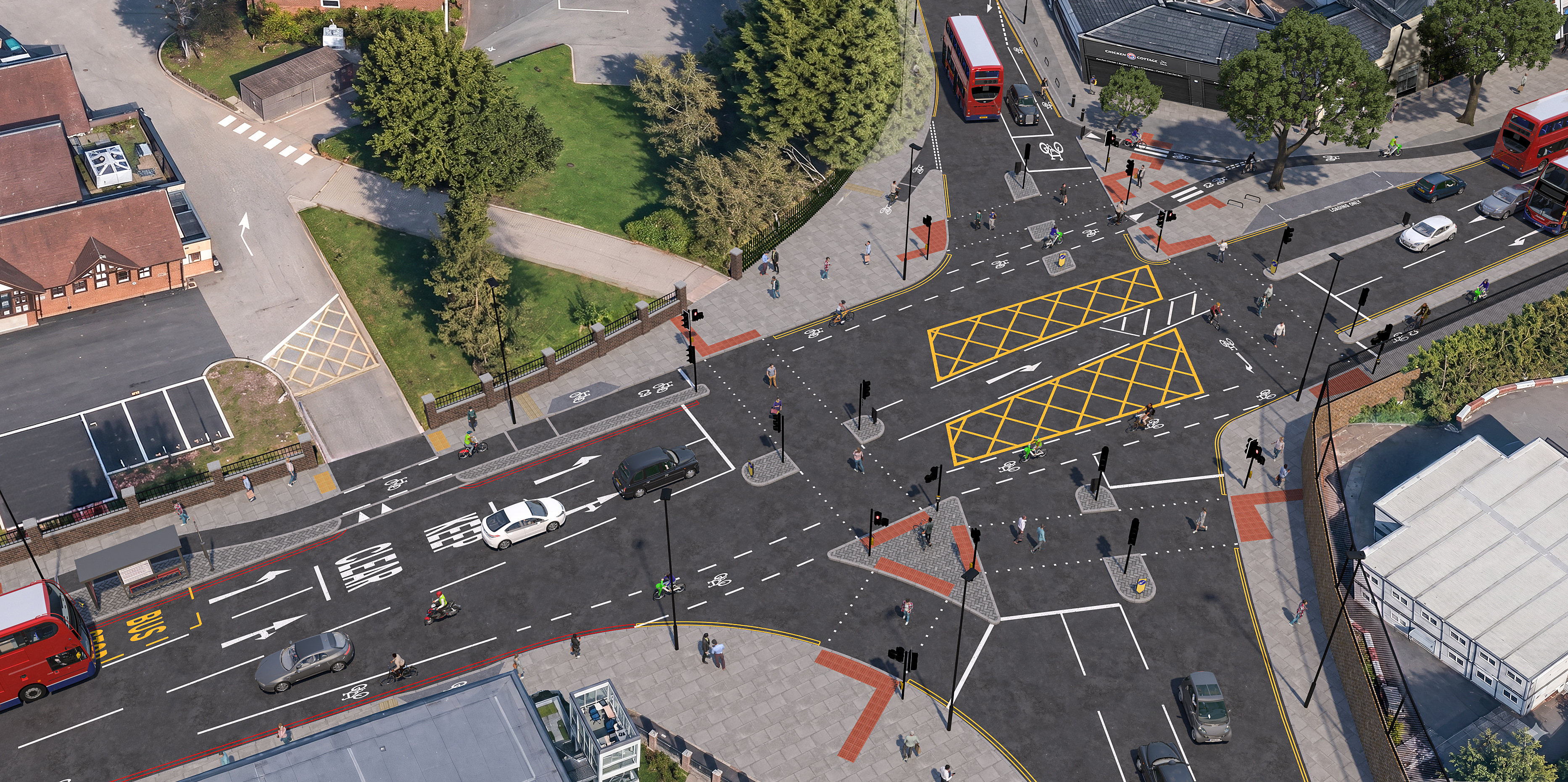 Busch Corner Junction illustrative visualisation of proposed scheme
In the summer 2024 we held a consultation on Brentford to Syon Park walking and cycling improvements (between Alexandra Road and Beech Avenue). The proposals we are now consulting on, cover the sections needed to complete the route from Syon Park to Hounslow town centre (between Beech Avenue and School Road/Laurence Road junction).
Similar improvements delivered along other sections of Cycleway 9 have already led to increases in cycling, with counts showing substantial growth in the number of people choosing to travel by bike. By extending the route, we aim to encourage even more people to make everyday journeys by cycle.
Safety is the main reason for the proposed improvements between Syon Park and Hounslow town centre. Data from the most recent three-year period (to late 2025) shows:
- 126 recorded road traffic collisions
- 37 collisions involving cyclists
- 25 collisions involving pedestrians
- 25 serious injury collisions
Our proposals are also in line with our Vision Zero strategy which aims to eradicate deaths and serious injuries from our roads. The proposals for this scheme have also been designed according to our Healthy Streets approach, which aims to make London a safer, healthier and greener place to live and travel.
How it may impact you
While the impact may vary for individuals, the proposals are expected to have a largely positive overall effect.Improvements for walking
The proposals include a range of improvements to make walking safer, easier and more comfortable. These include upgraded crossing facilities, safety improvements to side roads and junctions, and more space for pedestrians at key locations.
Key measures include wider zebra crossings, upgraded signal-controlled crossings, new pedestrian crossing opportunities, and changes such as footway build-outs and raised tables designed to reduce crossing distances, improve visibility and slow turning vehicles. Wider footways, larger pedestrian islands and waiting areas are also proposed at several locations along the route.
Improvements for cycling
The proposals will extend Cycleway 9 between Brentford and Hounslow, providing a more continuous route for people cycling. We would therefore expect people who cycle to benefit from our proposals.
The scheme includes new segregated cycle facilities, improvements at key junctions and crossings, safer side-road treatments, and floating bus stops which avoid cyclists having to pull out around buses and enhanced links to local destinations and existing cycle routes. These changes are intended to reduce interactions with motor traffic and provide a safer and more consistent cycling experience along the corridor.
Cycling levels have grown over recent years, with a 43% increase in journey stages between 2019 and 2025 across London. Recent data suggests there is already strong demand for cycling in the area - cycling levels on the completed Chiswick section of Cycleway 9 increased by between 25% and 40% between 2019 and 2024.
Changes impacting bus passengers
The proposals include changes to some bus stops and surrounding streets to help maintain reliable bus services while introducing new walking and cycling facilities. Improvements would make it easier and safer for passengers to access bus stops, including upgraded crossing facilities and changes to some bus stop locations along the route.
The scheme also includes new bus stop bypasses, at several locations, allowing cycle routes to pass behind bus stops. Mini zebra crossings would be provided to help passengers access bus stops safely and conveniently, with the designs following Transport for London and the Department for Transport’s best practice guidance.
Traffic and journey times
Our traffic modelling assessed journey times across the full route in both directions during the morning and evening peak periods. Predicted changes vary by direction and time of day, with general traffic journey times increasing by up to approximately 2 minutes eastbound and up to 3 minutes westbound across the route during the morning peak period assessed. Bus journey times are forecast to vary by direction and time of day, with increases of up to 100 seconds westbound and up to 50 seconds eastbound across the route. As with any forecast, actual journey times may differ from the modelled results because traffic conditions vary from day to day.
Other impacts
To enable the delivery of the proposed new cycle infrastructure, some trees will need to be removed. The locations of these trees are shown on the consultation maps. If any trees need to be removed as part of the scheme, we will seek opportunities to provide replacement trees in nearby locations, as has been done on other schemes.
During the detailed design stage, we will also continue to explore opportunities to introduce additional tress and other green infrastructure wherever possible. TfL's green infrastructure and biodiversity policies focus on protecting, connecting and enhancing green infrastructure across its network.
More information
We will be holding two drop-in events:
- Wednesday 23 September 2026, 14:00 - 18:00
Cooks Room, West Thames College, London Road, Isleworth, TW7 4HS - Saturday 10 October 2026, 10:00 - 14:00
Banks Room, West Thames College, London Road, Isleworth, TW7 4HS
These events will be staffed by TfL colleagues and are intended for anyone who would like to discuss the plans with us before submitting a response to the consultation.
If you are unable to attend these events but would still like to ask questions about the proposals, you can:
- Send an email to haveyoursay@tfl.gov.uk (please mark your email ‘Cycleway 9’)
- Call us on 020 3054 6037 and leave your name and contact number and we will call you back. Please quote ‘Cycleway 9’ when leaving your message
- Use our ‘Questions’ tool to submit a question to us directly
We also have published a range of additional information and background reports. These are available at each of the links below. The Equality Impact Assessment (EqIA) explains what effect our proposals would have on people with ‘protected characteristics’ and the Healthy Streets Check examines to what extent our proposals would meet TfL’s Healthy Streets Approach.
Accessible information
We want to make sure everyone can take part in our consultations. To help make it accessible to everyone we have provided our consultation information in the following formats:
 British Sign Language
 Easy Read
 Audio files
Translation
You can also translate the information on this page into another language by using the ‘Select language’ button at the bottom of the page
British Sign Language
 We are delighted to enable British Sign Language users to contact us using a British Sign Language video interpreter, via the Interpreters Live service, provided by Sign Solutions. Please click the image to connect now.
Easy Read
Audio files
Tell us your views
You can reply by completing our survey, which should take no more than 10 minutes to complete or if you are short on time, you can submit a quick response.
 |  |
The closing date for comments is Monday 19 October 2026.
Return to the top of the pageQuestions?
We have a series of FAQs where you can find answers to commonly asked questions. If you can’t find the answer you need or if you would like to discuss the proposals further with us, please get in touch and we can respond to your queries directly. You can do so by:
- Sending us an email to haveyoursay@tfl.gov.uk (please mark your email ‘Cycleway 9’)
- Call us on 020 3054 6037 and leave your name and contact number and we will call you back. Please quote ‘Cycleway 9’ when leaving your message
- Use our ‘Questions’ tool to submit a question to us directly
Next steps
The consultation will close on Monday 19 October 2026. After the consultation closes, we will review all the feedback we receive and publish a report on this webpage explaining what people told us and our next steps.
Return to the top of the page