Oxford Street - proposals for transport and highway changes
Consultation has concluded
We have published a consultation report to explain the outcomes of our consultation on proposed transport and highway changes to enable the pedestrianisation of the section of Oxford Street between Orchard Street and Great Portland Street.
The Mayor of London has now made a further announcement about these proposals, and we have written to all consultation respondents to share this update with them.
About our consultation
This consultation focuses on the proposed transport and highway changes to enable the pedestrianisation of the section of Oxford Street between Orchard Street and Great Portland Street – we call this section ‘Oxford Street West’ throughout this consultation. Any transport and highway changes that may be required in the future to enable the transformation of the remaining sections of Oxford Street would be subject to consultation at a later date.
 (Click on map for a larger version)
The purpose of our consultation
Following an extensive public consultation which closed in May 2025, the Mayor of London is continuing to develop proposals to pedestrianise Oxford Street, transforming it into a vibrant, green and world-class destination for Londoners and visitors alike. The previous consultation received over 6,000 responses, with almost seven in 10 Londoners showing support for the creation of a Mayoral Development Corporation. Of those that expressed a view, two out of three are in favour of pedestrianisation of the road specifically.
This next stage of consultation will focus on proposed transport and highways changes to Oxford Street to maximise the benefits that pedestrianisation could bring. The Mayor strongly believes that pedestrianisation has a vital part to play in the regeneration of Oxford Street to create a cleaner, safer, and more accessible public space where people can shop, dine, and gather in comfort and safety.
In this consultation our proposals for transport and highways changes to enable Oxford Street pedestrianisation, include:
- How we propose to amend the bus services that serve the area, including what routes the buses would take and where bus stops would be located
- How taxis and private hire vehicle services would be affected by the pedestrianisation of Oxford Street West
- Information about how people who currently cycle on Oxford Street West, or in the surrounding area, would be affected by the proposals
- Changes to the road itself, including how we could allow traffic to flow north-south through the area to navigate a pedestrianised Oxford Street West
- Information about how businesses on Oxford Street West would continue to make or take deliveries
- The impacts that our proposals would have on traffic flows, journey times, the environment and on the accessibility of Oxford Street West
If you have any suggestions for amendments you think we should make to our proposals, we would also like to know. The closing date for comments is 16 January 2026. For more information about how to respond please click the button ‘Tell us your views’.
Developing the proposals
The Mayor of London’s consultation earlier this year on the transformation of Oxford Street helped us to understand what thoughts the public and other stakeholders had about the principle of pedestrianising Oxford Street.
We listened carefully to all the feedback and, as much as possible, have used it to guide us in developing the proposals included in this consultation, or in determining what additional information we should include. For example, we recognised that some people were concerned about the impacts that pedestrianisation might have, and so we have included information about the expected effects of our proposals on the accessibility of Oxford Street West, the environment, traffic flows and journey times.
Over the last few months we have also met with a wide range of organisations to introduce our developing plans and the potential impact of them. These discussions have included representatives from emergency services, businesses in the Oxford Street area, local residents’ associations, taxi trade organisations and accessibility groups.
Highway Changes
This section explains how a pedestrian’s experience of using Oxford Street West could change with our proposed scheme in place. It provides more detail on the proposed changes to Oxford Street West and some of the roads in the surrounding area.
Why pedestrianise Oxford Street?
We propose that Oxford Street West be closed to private motorised vehicles, buses, taxis and private hire vehicles, cycles, scooters and pedicabs. The emergency services would have access at any time, and there would be a period from midnight to 07:00, when servicing vehicles could access Oxford Street West. We’ve described how and when freight and servicing vehicles would have access to Oxford Street West in the section labelled ‘Businesses, servicing and deliveries’.
Earlier this year the Mayor of London held a consultation on proposals to establish a new Mayoral Development Corporation for the Oxford Street area, and on the principle of pedestrianising the street. In June 2025 the Mayor published a consultation report which showed that over 6,000 people had responded to the consultation, and that around two thirds of those who responded on pedestrianisation were supportive of the principle of pedestrianising Oxford Street.
In this short video, people who use Oxford Street explain why they believe it should be pedestrianised:
We see several compelling reasons to pedestrianise Oxford Street. For example:
- It would help boost the West End's economy. GLA Economics estimate the mid-range of potential impacts of pedestrianisation to increase ‘Gross Valued Added’ (this is an economic indicator representing the value of goods and services produced in an area) by nearly £82m per year, whilst supporting a further 781 jobs. The analysis also states that pedestrianisation could raise £30-£40m in VAT receipts and £10- £20m in business rates depending on the scenario and outcomes
- It would reduce conflict between vehicles and pedestrians, making walking on Oxford Street West a safer and more relaxing experience. Currently, people are being hurt in collisions: from May 2022 until April 2025 there were 79 collisions along Oxford Street West and its junctions. These collisions resulted in 24 serious injuries and 54 per cent of those who were injured were pedestrians
- Pedestrianising Oxford Street West would provide more space for people and help create a safe and more pleasant overall experience. High levels of pedestrian overcrowding on Oxford Street and in the wider area continue to have a negative impact on the visitor experience. Not only does it discourage visitors from coming into the area, but it also reduces the amount of time people are willing to stay in the area
- The one-day traffic free trial (This is Oxford Street) in September successfully demonstrated the potential of a pedestrianised Oxford Street. The event delivered a vibrant, safe, and inclusive experience for visitors, supported retailers and showed a glimpse of what Oxford Street could look like. With nearly 70 per cent of stores on the street that were surveyed reporting similar or higher sales than a typical Sunday
- This is Oxford Street gave people a chance to feel what the space would be like, traffic-free. More than three quarters of people surveyed on the day said the event improved their experience of visiting Oxford Street, while more than half specifically liked the increased pedestrian space
- The event also delivered a significant boost to the local economy, with footfall in the area 45 per cent higher than the week before and the number of passengers using tube stations serving Oxford Street - Marble Arch, Bond Street and Oxford Circus up - by a quarter compared to the previous Sunday
A transformed Oxford Street
We propose that Oxford Street West be closed to private motorised vehicles, buses, taxis and private hire vehicles, cycles, scooters and pedicabs. The emergency services would have access at any time, and there would be a period from midnight to 07:00, when servicing vehicles could access Oxford Street West. We’ve described how and when freight and servicing vehicles would have access to Oxford Street West in the section labelled ‘Businesses, servicing and deliveries’.
North-South routes for traffic
Our proposals would maintain several routes for traffic heading north to south (or vice versa) to cross the pedestrianised section. We propose to allow traffic to cross Oxford Street West at the junctions listed below.
- Duke Street (for traffic heading northbound only)
- Davies Street and Stratford Place
- Vere Street and New Bond Street (for traffic heading southbound only)
- Holles Street and Harewood Place (for traffic heading northbound, and we propose also to provide a contraflow cycle lane for cyclists to travel southbound)
Regent Street would also remain open to traffic under our proposals. We are aware of proposals being developed by Westminster City Council for further changes to Regent Street and are working with them to co-ordinate our proposals
As part of the changes, we are proposing to provide pedestrian crossings controlled by traffic lights at these junctions to ensure pedestrians using Oxford Street West are aware that traffic will pass here, and to help them cross at these points.
These pedestrian crossings would be much wider than is currently the case, providing more space for pedestrians to wait to cross. This is important because, at some junctions on Oxford Street West, there is currently very little room for pedestrians to wait for a signal to cross. In turn, crowding at these junctions increases the risk of a pedestrian being hurt in a collision.
The crowding may cause some pedestrians to cross when it is not safe to do so. From May 2022 until April 2025 there were 79 collisions on Oxford Street West and its junctions. These collisions resulted in 24 serious injuries and 54 per cent of those who were injured were pedestrians. By reducing conflict between vehicles and pedestrians, pedestrianisation would make walking on Oxford Street West a safer and more relaxing experience. Our proposals would also give pedestrians much greater priority at north-south crossing points, reducing the time pedestrians would need to wait for a signal to cross.
The proposed changes would also require some changes to roads surrounding Oxford Street West. These roads are managed by Westminster City Council who we will continue to work with. The changes include:
- Minor layout changes to help buses more easily navigate the junctions of Baker Street and Wigmore Street, and Great Portland Street and Oxford Street. This would help keep bus journeys reliable
- New bus stands, which are used to ensure buses can operate reliably, at Margaret Street, Great Portland Street, Hanover Street and North Row
- Conversion of Henrietta Place from one-way to two-way, to allow traffic to operate in both directions here
- Two new pairs of bus stops on Wigmore Street and Henrietta Place
- Changing the Great Castle Street one-way system from westbound to eastbound, to enable buses to travel eastbound here
- Providing new pedestrian crossings on Regent Street, at its junction with Oxford Circus
- A new contraflow cycle lane for southbound cyclists on Holles Street and Harewood Place
- Allowing buses and taxis only to turn right from Orchard Street onto Wigmore Street
- Making Great Castle Street eastbound from its junction with Regent Street
- Removing a small section of central reservation on Great Castle Stret near its junction with Regent Street to help buses navigate this junction
- Allowing traffic to operate in both directions on some parts of Gilbert Street and Binney Street
- Allowing traffic to operate in both directions on Weighouse Street between its junctions with Gilbert Street and Davies Street
- Reversing the direction that traffic would flow on the east and west arms of Cavendish Square, and also on Park Street and North Audley Street
The map below illustrates the changes we propose to make:
 (Click on map for a larger version)
Except at the crossing points described above for traffic heading north-south (or vice versa), all other side roads leading off Oxford Street West would be closed with bollards or other features, to keep pedestrians safe and secure.
Security and access for the emergency services
We have worked closely with the emergency services to understand their requirements and ensure that if our proposals were implemented, access to Oxford Street West would be maintained for the Metropolitan Police Service (MPS), London Fire Brigade (LFB) and London Ambulance Service (LAS).
We have also worked closely with the Metropolitan Police Service and other agencies to ensure that access to Oxford Street West would be for the emergency services and freight and servicing vehicles (from midnight to 07:00) only. We would achieve this by placing bollards or other features on closed roads which would open and close to enable access only for the emergency services or for overnight servicing.
Delivering the pedestrianisation of Oxford Street West
Depending on the outcomes of this consultation, the pedestrianisation of Oxford Street West would be delivered in stages working in partnership with the relevant local authorities. Firstly, it would be necessary for various preparatory works to take place. These would make it possible for buses to be diverted away from Oxford Street West. Once these are complete it would then be possible to close Oxford Street West to traffic, and to begin works to make it a more attractive location for pedestrians.
Buses, taxis and cyclists
This section includes the changes we propose to make to the bus routes and taxi services which currently use Oxford Street West. It also explains what alternatives to Oxford Street West could be provided for people who currently cycle here.
Changes to bus services
Bus routes 7, 94, 98, 139 and 390 currently run on Oxford Street West during the day and routes N7, 94, N98, N113, N137, 139, N207 and 390 run here at night. We have thought very carefully about what bus route changes could be necessary to allow pedestrianisation to happen and propose making a number of changes. We’ve also indicated how passengers which use these routes would continue their journey in each case.
Check here to find out how your journey may change during the day and night. Under our proposals they would all continue to run at their existing frequencies. We are not proposing to make any other changes to these routes.
Some bus services which do not operate along Oxford Street West would also be affected by our proposals. You can find out more about how these routes would operate during the day and night, the start and end point of each route currently, and what changes we propose to make. We’ve also indicated how passengers which use these routes would continue their journey in each case.
The following graphic shows how these routes would serve the Oxford Street area in future under our proposals, including their new destinations and how passengers could interchange between them. We have provided maps to show what changes would be made to routes which operate during the day and those which operate at night.
 (Click on map for a larger version)
Changes to bus stops and stands
In some cases, pedestrianisation would mean that walking distances from bus stops to stores on Oxford Street and Wigmore Street would be reduced. This is because destinations on the north-side of Oxford Street West would be closer to bus services using Wigmore Street. Except for the north-south crossing points we described above, our proposals would mean that pedestrians could cross Oxford Street West at any point rather than walking to a pedestrian crossing.
For people wishing to access Oxford Street West directly by bus, the changes we propose would mean that they would have to walk a short additional distance to and from their bus. The stops would be approximately 100m to 200m from Oxford Street, depending on the final detailed designs.
New seating and rest areas would however form part of the planned urban realm improvements to Oxford Street West. We would also work with Westminster City Council to improve the condition of footways in the surrounding area: this would help those with accessibility requirements to get to and from Oxford Street West and surrounding bus stops, taxi pick up/drop off locations and tube stations.
Those people who travel beyond Oxford Street West may need to change buses to complete their journey, depending on where they are travelling to and from. We have produced an Equalities Impact Assessment which looks in detail at the impacts our proposals would be expected to have on the accessibility of Oxford Street West.
This map shows the routes for buses on routes 98, 139 and 390 that would run along Wigmore Street and Henrietta Place under our proposals in the day and routes N98, 139, 390 and N207 at night Again, we have provided a map to show changes to routes which run during the day, and a separate map to show routes which run at night.


Changes to taxi and private hire services
Taxi and private hire services are crucial elements of London’s transport network. We consider that our proposals to pedestrianise Oxford Street West would support the taxi and private hire industries. This is because the pedestrianisation of Oxford Street West is intended to transform the street and make it a much more attractive place to be. This would increase the demand for travel to Oxford Street in general, including by taxi and private hire vehicles.
The pedestrianisation of Oxford Street West would necessitate the removal of the existing taxi rank outside Selfridges on Oxford Street. We recognise the importance of taxi ranks to the trade however and we are discussing with Westminster City Council the potential for additional ranking space elsewhere on the roads surrounding Oxford Street West. The potential new locations for ranks are:
- New rank outside the Selfridges Food Hall entrance on Orchard Street for up to four taxis
- The existing taxi rank at Duke Street would be extended so that it provides capacity for six taxis (it currently provides capacity for two taxis)
- A possible new rank at the southern end of Holles Street to provide capacity for two taxis
- John Prince’s Street: A new rank on John Prince’s Street to provide capacity for five taxis
All of these ranks are very close to Oxford Street West, and this is indicated in the map above. The maximum distance from the furthest rank to Oxford Street West, which is outside Selfridges, is 70 metres.
The button ‘Highway Changes’ explains what changes overall would be made to Oxford Street West and in the surrounding area.
Cycling
Supporting more people to travel sustainably, including by cycling, is a key priority for TfL and the Mayor and we are continuing to invest in new infrastructure to support people cycling safely.
Pedestrianising Oxford Street West would create a new space for pedestrians to enjoy, and we do not consider this pedestrianised area would be compatible with people cycling or using scooters to travel along Oxford Street. For this reason, we propose that cycling would not be allowed on Oxford Street West. This would include e-bikes and e-scooters. Mobility scooters would of course be permitted access.
However, we recognise the need to provide high-quality alternative routes through the area. We will work closely with Westminster City Council to support the development of these proposals. Westminster City Council is continuing to make improvements to cycle routes in the area linking Marylebone, Fitzrovia, Hyde Park and Paddington. Details are available on Westminster's website: https://www.westminster.gov.uk/roads-and-travel/walking-and-cycling/cycle-strategy
The button ‘Highway Changes’ explains what overall changes would be made to Oxford Street West and in the surrounding area.
Businesses, servicing and deliveries
This section explains what arrangements we propose to make to ensure that businesses on Oxford Street West could continue to make and take deliveries if our proposals were implemented. This is important because many of the existing businesses that trade on Oxford Street West can only be accessed from Oxford Street itself, either for restocking or maintenance.
Servicing vehicles would be allowed into and out of Oxford Street West at several points along the street, creating servicing vehicle ‘loops’. These are illustrated in the map below.
We propose that the servicing vehicles would be able to access these routes every day from midnight to 07:00, when our monitoring shows that the number of pedestrians using Oxford Street West is relatively low. Any deliveries or servicing between 07:00 and midnight would need to take place via designated loading bays in the streets surrounding Oxford Street West.
Over the last few months we have discussed our proposals with the businesses that would be directly affected. For this reason, we are confident that our proposals balance the needs of businesses on Oxford Street West with the wider benefits of pedestrianisation, and bearing in mind the need to keep any disruption to residents to a minimum. We propose however to go further, and to continue to support and encourage businesses to adapt if Oxford Street West is transformed. We explain this work below.
Reducing the impacts of servicing and supporting businesses to adapt
Oxford Street West can lead the way in showing how deliveries and servicing can be cleaner, quieter and more efficient. TfL would work with the soon-to-be created Mayoral Development Corporation to support freight consolidation practices.
We’ll continue to work with businesses to reduce the number of delivery trips, support them in shifting to zero-emission vehicles like cargo bikes and electric vans, and re-time servicing to fit proposed hours. This will mean quieter freight vehicles, cleaner air and safer streets. We are also exploring options to incorporate consolidation of goods, delivery and supply trips, and joint procurement of waste, into the designs. We will work closely with the forthcoming Mayoral Development Corporation to identify potential operating models, and will announce further details in due course.
By supporting innovation and working closely with businesses, freight operators and landowners, we’ll help Oxford Street West adapt to pedestrianisation while keeping goods and services moving.
Main impacts and benefits
This section describes what effects our proposals are expected to have on:
- Traffic
- Air quality and
- Noise levels
Traffic impacts
We have developed a traffic model to show what effects our proposals would be expected to have on traffic levels and journey times. It is expected that buses, taxis and cycles currently using Oxford Street would use a range of nearby adjacent routes if our proposals were implemented.
Our traffic model does not differentiate between taxis, cars and freight vehicles, so it is not possible for us to provide information about what specific journey time changes there might be for taxis or private hire vehicles.
We propose that taxis would no longer have access to Oxford Street West (private hire vehicles are already restricted from using Oxford Street), and would instead use Wigmore Street, or other surrounding streets to access the area or travel around it.
The results of our traffic modelling are presented for the AM / morning (08:30 to 09:30) and PM / evening (18:00 to 19:00).
In summary we found that:
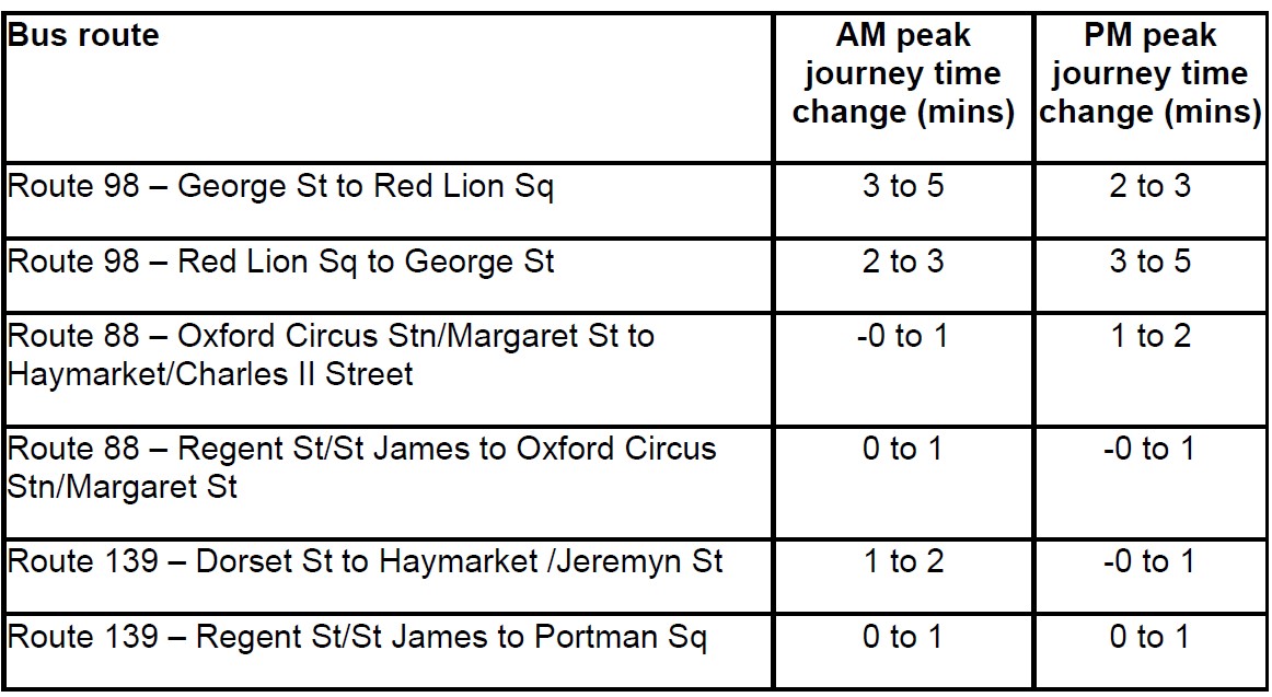
Bus journey time
- Most local bus routes would operate similar journey times, seeing an overall change of a minute or less in both the AM and / or PM peak
- The route that would experience the largest increase in journey time is route 98 and the 390. These routes previously used Oxford Street and are proposed to use a longer route via Wigmore St
- Route 98 towards Pound Lane would see journey times increase 2 to 3 minutes in the AM and 3 to 5 minutes in the PM peak
- Route 98 towards Red Lion Square would see journey times increase 3 to 5 minutes in the AM and 2 to 3 minutes in the PM peak
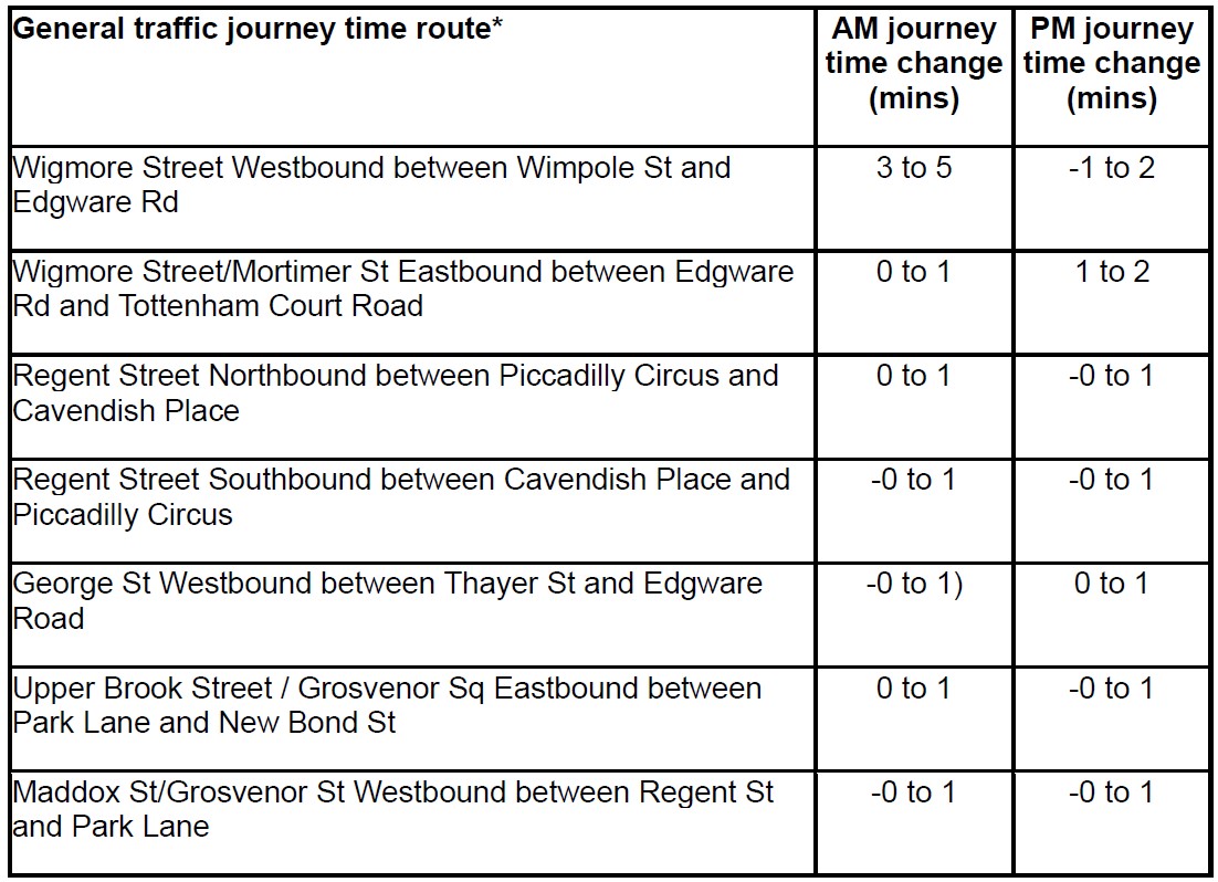
General traffic journey time
- Most of the routes for general traffic would operate similar journey times, seeing an overall change of a minute or less in both the AM and / or PM peak
- Road users choosing to use Wigmore Street as an alternative westbound route would see a journey time increase of 3 to 5 minutes in the AM Peak and a decrease of -1 to -2 minutes in the PM peak
- Road users choosing to use Wigmore Street and Mortimer St as an alternative eastbound route would see a journey time increase of 0 to 1 minutes in the AM Peak and an increase of 1 to 2 minutes in the PM peak
Traffic flow
Pedestrianisation and the associated road network changes would be expected to result in individuals choosing different routes to complete their journey. The following outlines the changes on key local routes around the pedestrianised area:
- Wigmore Street Eastbound between Mandeville Place and Duke St an increase of 50 to 100 vehicles in the AM peak and 0 to 50 vehicles in the PM peak is expected.
- Wigmore Street Westbound between Mandeville Place and Duke St an increase of 50 to 100 vehicles in the AM peak and a decrease of -100 to -50 vehicles in the PM peak is expected.
- Brook St Westbound between Gilbert St to Davies St is expected to have an increase of 100 to 200 vehicles in the AM and PM peak. At the same location, Brook St Eastbound is expected to see a decrease -100 to -50 vehicles in the AM peak and -100 to -200 vehicles in the PM peaks
- Regent Street Southbound is expected to have an increase of 200 to 300 vehicles in the AM peak and a 100 to 200 vehicles increase in the PM peak. The same northbound route on Regent Street is forecasted to experience an increase of 0 to 50 vehicles in the AM and PM peak
For further traffic modelling information, for both impacts on journey times and traffic flow, please click this link .
Air quality
Our assessment considers the current levels of air quality for (i) Oxford Street and Central London, (ii) a future situation without the Oxford Street West Proposals, and (iii) a future situation with Oxford Street West Proposals.
We assessed Nitrogen Dioxide (NO2), Particulate Matter (PM2.5 and PM10) at 85 selected sensitive locations such as homes, schools, hospitals and local community buildings and spaces within the study area. Carbon Dioxide (CO₂) emissions have been calculated based on total road traffic volumes. In summary we found that if we implemented our proposals:
- 6 locations are predicted to benefit from improved NO₂ levels, 4 of which are within the scheme area
- 24 locations are expected to see a fractional decrease in NO₂, of 0.1 µg/m³
- 43 locations are expected to see a fractional increase in NO₂ of 0.1 µg/m³
- PM10 and PM2.5 levels fall below the limit values of 40 µg/m³ and 20 µg/m³ respectively
- Total CO₂ emissions from all modelled roads in the study area with the scheme would be 21,553 tonnes per year
If you want to find out more please click this link .
Noise
Our noise assessment considers (i) the current levels of noise for Oxford Street and Central London, (ii) the future situation without the Oxford Street West Proposals, and (iii) the future situation with Oxford Street West Proposals.
In summary we found that if we implemented our proposals:
- With the Proposed Scheme in place traffic noise still dominates the study area but high traffic noise levels are no longer predicted in many parts of central London, including: Oxford Street, Bryanston Street, Wimpole Street, Great Castle Street, Vere Street, James Street, North Audley Street, South Audley Street and South Molton Street
- The largest reductions in traffic noise are expected on Oxford Street, Bryanston Street and James Street which see reduction in noise between 11.1dB and 24.1dB
- However, because of Oxford Street closing to traffic some roads experience an increase in road traffic noise because of re-routed traffic. Some areas are expected to become subject to higher levels of traffic noise, which include: Margaret Street, Upper Brook Street, Marylebone Lane, Dunraven Street and Stratford Place which see an increase in noise between 3.2dB and 7.8dB
If you want to find out more please click this link .
Accessibility
We have produced an Equalities Impact Assessment (EqIA) and Appendix B which looks in detail at the impacts our proposals would have on the accessibility of Oxford Street West if our proposals were implemented.
In summary we found that:
- Our pedestrianisation proposals should significantly improve the overwhelming and disorienting nature of crowding that is common on Oxford Street
- Pedestrianisation would significantly reduce road danger risks for pedestrians
- Older people, disabled people and women (including pregnant women), that have higher rates of bus and taxi usage, would be impacted as the proposals restrict bus and taxi access to Oxford Street
- However, these groups would also find it easier to use Oxford Street as a result of having more pedestrian space, a level pavement surface and more seating and resting places
We recognise that pedestrianising Oxford Street West would have a material impact on how the area is accessed, both in terms of how people reach Oxford Street and how people move around once they are there.
Except for taxis and buses, motor vehicle access to Oxford Street West is currently restricted from 07:00 to 19:00 from Monday to Saturday inclusive. While buses and taxis would no longer be able to access a pedestrianised Oxford Street West directly, our proposals have sought to provide for bus stops, taxi ranks and drop-off locations to be located as close to the pedestrianised area as possible. We have also maintained the number of blue badge parking bays in the area.
We believe that pedestrianising Oxford Street West would improve everyone’s overall experience of using it. Our proposals include creating a level environment along the length of Oxford Street West, improving accessibility for all pedestrians.
New seating and rest areas would form part of the planned urban realm improvements and we would also work with Westminster City Council to improve the condition of footways in the surrounding area: this would help those with accessibility requirements to get to and from Oxford Street West and surrounding bus stops, taxi pick up/drop off locations and tube stations.
The accessibility of the Oxford Street area has improved considerably following the opening of the Elizabeth line in May 2022, with the introduction of step-free access at Tottenham Court Road and Bond Street stations, whilst London’s bus network and taxi fleets have been accessible for many years.
We have produced an Equalities Impact Assessment which looks in detail at the impacts our proposals would be expected to have on the accessibility of Oxford Street West.
A summary of the main findings is below. The full document is available to download from the ‘More information’ button.
- The pedestrianisation of Oxford Street would create more dedicated pedestrian space along Oxford Street and should significantly improve the overwhelming and disorienting nature of crowding that is common
- By removing most traffic from Oxford Street, pedestrianisation is likely to reduce road danger risks for pedestrians
- Older people, disabled people and women (including pregnant women) would find it easier to use Oxford Street as a result of having more pedestrian space, a level pavement surface and more seating and resting places. Pedestrianisation would restrict bus and taxi access to Oxford Street, and result in rerouting buses and taxis to adjacent streets. We know that older people, disabled people and women (including pregnant women) have higher rates of bus and taxi usage, therefore the changes set out may have a greater impact on those groups
More Information
We will be holding four drop-in events:
- 5 December 2025, 12:00 – 16:00, David Wolf Kaye room, Wigmore Hall, 36 Wigmore Street W1U 2BP
- 13 December 2025, 13:00 - 17:00, Princes St room, Salvation Army Regent Hall, 275 Oxford Street W1C 2DJ (Please use the entrance on Princes Street)
- 9 January 2026, 12:00 – 16:00, David Wolf Kaye room, Wigmore Hall, 36 Wigmore Street W1U 2BP
- 10 January 2026, 13:00 – 17:00, Princes St room, Salvation Army Regent Hall, 275 Oxford Street W1C 2DJ (Please use the entrance on Princes Street)
These events will be staffed by TfL staff who have been involved in the development of our proposals for Oxford Street West, and are intended for people who need to discuss something with us to help them to respond.
Please note that the Princes Street room at Regent Hall is not fully accessible, although the David Wolf Kaye room at Wigmore Hall is accessible by lift. If you have a question that you would like to discuss with us and require an accessible venue but are not able to attend our dates at Wigmore Hall, please contact us using the details below so that we can respond to your questions.
If you are unable to attend these events but would like to discuss the proposals further with us, please get in touch and we can respond to your queries directly. You can do so by:
- Sending us an email to haveyoursay@tfl.gov.uk (please mark your email ‘Oxford Street’)
- Call us on 020 3054 6037 and leave your name and contact number and we will call you back. Please quote ‘Oxford Street’ when leaving your message
- Write to FREEPOST TfL HAVE YOUR SAY (no postage stamp required)
- Use our 'Questions' tool to submit a question to us directly
Connecting with London's deaf community on our consultations
To further enhance how we consult with London's deaf community we offer:
- A British Sign Language (BSL) video of our proposals and survey
- A BSL conversation service. This allows the TfL consultation lead to have a two-way BSL translated discussion with a BSL user. To request a BSL conversation please contact us at haveyoursay@tfl.gov.uk and we will be in contact to arrange a convenient time
Accessible Information
We want to make sure everyone is able to take part in our consultations. To help make it accessible to everyone we have provided:
You can translate the information on this page into another language by using the ‘Select language’ button at the bottom of the page.
We have published a range of additional information and background reports. These are available at each of the links below. We have also provided more information to help you respond and a set of Frequently Asked Questions.
Tell us your views
You can reply by completing our survey, which should take no more than 10 minutes to complete or if you are short on time, you can submit a quick response.
 |
The closing date for comments is Friday 16 January 2026.
-
Traffic impacts
Share Traffic impacts on Facebook Share Traffic impacts on X (formerly Twitter) Share Traffic impacts on Linkedin Email Traffic impacts linkConsultation has concludedWe have developed a traffic model to show what effects our proposals would be expected to have on traffic levels and journey times. This allows us to predict what travel impact the proposed changes could have on road users and bus passengers for the busiest times of the day, with results presented for the morning (08:30 to 09:30) and evening (18:00 to 19:00).
A traffic model is a representation of real-world conditions, developed to replicate traffic operation at a defined point in time. It is built using actual traffic data and tested to ensure that it reflects the road network as much as possible. The model can then be adapted to test the operational impacts of proposed changes, with any assumptions based on available evidence and recorded for transparency.
Modelling provides a simulated environment in which proposals can be assessed without the cost or disruption of real-world trials, and potential impacts on traffic flow, journey time and network capacity to be understood.
Traffic models are developed with care to ensure that any simplifications remain appropriate and do not detract from their overall usefulness. These considerations will be considered when interpreting the results, helping to provide a clear and well-supported understanding of the likely impacts.
How will my bus journey change because of the proposed pedestrianisation?
Due to the changes to the network which could result from the pedestrianisation of Oxford Street West in accordance with our proposals, some bus routes, such as route 98, that currently travel along Oxford Street, would operate on Wigmore Street and Henrietta Place between Orchard Street and Great Portland Street.
The changes we have proposed mean that people travelling on bus route 98 eastbound are forecasted to experience a longer journey time of 2 to 3 minutes during the evening peak, and a longer journey time of 3 to 5 minutes during the morning peak, if the proposals are implemented.
For the route 98 westbound during the evening peaks, journey times would be expected to increase by 3 to 5 minutes.
On other bus routes, like routes 88 which operates along Regent Street, bus passengers would be expected to have a similar experience with a reduction of up to 1 minute when travelling northbound during the evening peak. During the same peak, southbound bus passenger can expect an increase of 1 to 2 minutes as a result of the Oxford Street pedestrianisation proposal.
The table below shows journey time changes for all those bus routes that would be affected by the proposed pedestrianisation of Oxford Street West. Bus routes not included in this table would not be affected by our proposals.
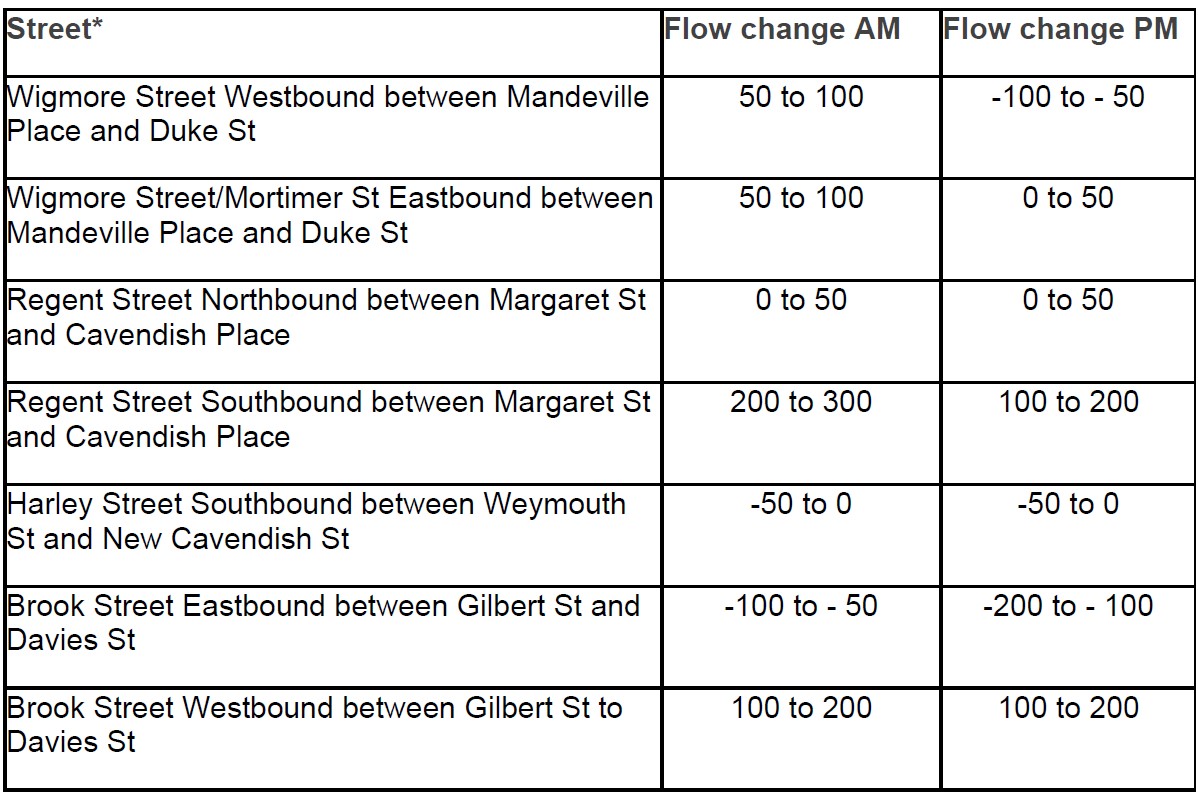
How will traffic flows change in the local area?
Pedestrianisation and the associated road network changes would be expected to result in individuals choosing different routes to complete their journeys: we call this ‘redistribution’. It is expected that buses, taxis and cycles currently using Oxford Street would, if our proposals were implemented, use a range of nearby adjacent routes.
As a result, we forecast that there would be an increase of 0 to 50 vehicles using Wigmore Street between Mandeville Road and Duke Street in the eastbound direction during the evening peak and Wigmore St westbound during the PM peak would be expected to see a decrease of -100 to -50 vehicles.
Other alternative routes such as Brook Street eastbound would see a decrease of -200 to -100 vehicles in the evening peak and Harley Street Southbound would see a change of -50 to 0 vehicle in the evening peak.
The table below shows selected traffic flow changes: we have selected the streets included in the table because we consider that these are the key routes which are likely to see a change in traffic flows. Additional information on traffic flow changes within the modelling study area is available here.
What will be the journey time changes for other traffic?
Due to the forecasted redistribution of traffic and road network alterations, journey times for traffic other than buses are also expected to change if our proposals are implemented. For example, an eastbound journey on Wigmore Street and Mortimer St between Edgware Road and Tottenham Court Road would increase by 1 to 2 minutes in the evening peak. Westbound journeys on Wigmore Street between Wimpole St and Edgware Rd during the evening peak are expected to have a 1 to 2 minutes decrease in journey times. We anticipate some journey times will remain the same or reduce.
Our traffic model does not differentiate between taxis, cars and freight vehicles, so it is not possible for us to provide information about what specific journey time changes there might be for taxis or private hire vehicles.
We propose that taxis would no longer have access to Oxford Street West (private hire vehicles are already restricted from using Oxford Street), and would instead use Wigmore Street, or other surrounding streets to access the area or travel around it. We have described in the following section what journey time changes there would be for general traffic in the area surrounding Oxford Street West.
The table below shows selected general traffic journey time changes along streets in the vicinity of Oxford Street. We have selected the streets included in the table because we consider that these are the key routes which are likely to see a change in traffic flows. Additional information on journey time changes for other traffic using additional roads is available here.
-
Air quality
Share Air quality on Facebook Share Air quality on X (formerly Twitter) Share Air quality on Linkedin Email Air quality linkConsultation has concludedWe have undertaken an Air Quality assessment to understand what the likely impacts would be of pedestrianising Oxford Street west in accordance with our proposals. This work is being supported by external independent consultants who have undertaken modelling work for us. The assessment covers key air pollutants, Nitrogen Dioxide (NO2), Particulate Matter (PM2.5 and PM10) at 85 selected sensitive locations such as homes, schools, hospitals and local community buildings and spaces within the study area. Carbon Dioxide (CO₂) emissions have been calculated based on total road traffic volumes.
The work has used outputs from the traffic modelling to ensure consistency and accuracy of our model predictions. We have also been undertaking monitoring of existing Air Quality levels in and around Oxford Street west to underpin the assessments.
NO2 and Particulate Matter are pollutants which cause the greatest concern to public health. These impacts occur from emissions from road vehicles and traffic flow rates, fleet composition and vehicle speeds which all affect the levels of air pollution. NO2, PM10 and PM2.5 are measured in micrograms per cubic meter of air (μg/m3). The Air Quality Standards Regulations 2010 set out the legal limits (called ‘limit values’) for concentrations of pollutants in outdoor air. In addition, the World Health Organisation and the Mayor of London have also set out recommendations for targets pollutants concentrations which are lower than the legal limits.
How have the air quality impacts been determined?
The air quality modelling is based on traffic speed and flow data from the traffic reassignment model used to understand traffic flow changes on London’s road Network. The outputs from the traffic model are fed into the air models which allows us to understand what the forecasted changes are in air quality associated with the proposed scheme are likely to be.
The assessments consider the following scenarios:
- Baseline Situation: the current standards of air quality for Oxford Street and Central London
- Future Situation without Oxford Street West Proposals: the current baseline situation but with other developments that have planning permission and other road improvements planned for implementation up to 2026
-
Future Situation with Oxford Street West Proposals: the Oxford Street proposals and other committed developments that have planning permission and road improvements planned for implementation up to 2026
What are the potential impacts, what does this mean for me?
Current Baseline situationIn 2024, annual average NO2 levels on Oxford Street west and at the majority of locations within the study area were below the limit value of 40 micrograms per cubic metre (µg/m³) at ³). However three locations on Piccadilly (London Park School and nearby residential buildings on the first and second floors), are above the limit value. The highest level was recorded 49.1 µg/m³ at London Park school, which aligns with recent monitoring nearby which recorded levels above 50 µg/m³.
In 2024, concentrations of both PM10 (larger particles) and PM2.5 (finer particles) across the study areas including Oxford Street west, are well below the limit values 40 µg/m³ and 20 µg/m³ respectively. However, current PM2.5 levels are close to or above the 2028 interim air quality target of 12 µg/m³ and exceed the Mayor of London’s target of 10 µg/m³.
The total baseline CO₂ emissions in 2024 from all modelled roads in the study area are 24,390 tonnes per year.
Key findings from the Future Situation Without the Scheme
NO2 concentrations decrease from the baseline situation due to tighter vehicle legislation, local road improvement schemes, broader Mayoral and local policies such as ULEZ, cleaner vehicles and increased uptake of electric vehicles. These initiatives will continue to improve concentrations, and the downward trend is expected to continue which will improve air quality levels over time.
In 2026, locations on Oxford Street west and at the majority of locations within the study area are below the limit value NO₂ limit of 40 µg/m³. However, two locations on Piccadilly (London Park School and a first-floor residential building) are forecast to be above the limit value NO₂ limit of 40 µg/m³. The highest level remains at London Park School, with a forecast concentration of 42.6 µg/m³. However, the NO ₂ levels across the entire study area without the scheme are lower than the current 2024 baseline.
The map below shows the changes in NO₂ concentration levels for the “without scheme” scenario compared to the “with scheme” scenario at selected receptors across the study area.
Across the study area including Oxford Street west, concentrations of both PM10 and PM2.5 are still below the limit values 40 µg/m³ and 20 µg/m³ respectively. However, as with the baseline, PM2.5 levels across the study area remain close to or are just above the 2028 interim target of 12 µg/m³ in 2026. Only two first-floor residential locations on Grosvenor Street and New Bond Street are forecast to meet the mayoral target of 10 µg/m³. All other locations including Oxford Street west are above this target but are under the limit values.
Total CO₂ emissions in 2026 from all modelled roads in the study area without the scheme are 21,984 tonnes per year. Between 2024 and 2026, across the entire modelled road network in the study area, road traffic related CO₂ emissions naturally go down due to improvements in the fleet (by 10%).
Key findings from the Future Situation with the Scheme
Our modelling shows that at the majority of locations in the Oxford Street West area, pedestrianisation would have no material effect on air quality. In fact, several locations in the area are predicted to benefit from improved NO₂ levels.
With the scheme in place, locations on Oxford Street west and at the majority of locations within the study area are still below the limit value NO₂ limit of 40 µg/m³. The same two locations on Piccadilly (London Park School and a first-floor residential building) are still forecast to be above the limit values.
However, with the scheme in place and when compared to the 2026 without scheme scenario, there are imperceptible increases of NO₂ levels at locations across the study area. There are slight increases at the London Park School and the first-floor residential building where there is a forecast increase of 0.4 µg/m³ and 0.5 µg/m³ respectively. There are also slight increases at ground-floor homes on Brook Street and Upper Brook Street.
In summary, the NO₂ levels across the study area with the Oxford Street west scheme in place are:
- 43 locations are expected to see an increase in NO₂ of 0.1 µg/m³. This is considered to be imperceptible
- 24 locations are expected to see a decrease in NO₂ of more than 0.1 µg/m³. This is considered to be imperceptible
- The largest increase (2.1 µg/m³) is at a ground-floor residence on Upper Brook Street
- The largest decrease (3.5 µg/m³) at a first-floor residence on Oxford Street west
- 6 locations are predicted to benefit from improved NO₂ levels, 4 of which are within the scheme area
The map below shows the future NO₂ concentration levels with the scheme at selected receptors across the study area.
With the scheme in place, concentrations of both PM10 and PM2.5 still fall below the limit values 40 µg/m³ and 20 µg/m³ respectively across the study area including Oxford Street West. However, as with the 2026 without scheme scenario, PM2.5 levels remain close to or just above the 2028 interim target of 12 µg/m³. Only one first-floor residence on New Bond Street is forecast to meet the mayoral target of 10 µg/m³. The highest modelled annual average levels are: PM10: 25.0 µg/m³ and PM2.5: 13.2 µg/m³ which occur on Park Lane however these forecasts are still below the limit values.
Total CO₂ emissions in 2026 from all modelled roads in the study area with the scheme are 21,553 tonnes per year. There is a slight reduction of 2% in CO₂ emissions associated with the scheme when compared to 2026 without the scheme, due to a small overall reduction in vehicle kilometres travelled.
Summary
While air quality modelling shows exceedances of the NO₂ annual limit value (40 µg/m³) at locations on Piccadilly, including London Park School, recent monitoring data across central London indicates a clear downward trend in pollution levels.
From 2022 onwards, all automatic and the majority of non-automatic air quality monitoring sites have recorded consistent reductions in NO₂ concentrations, with all automatic sites meeting legal limits in 2024. This improvement is driven by:
- Stricter vehicle emissions standards through the implementation of the Ultra Low Emission Zone (ULEZ)
- Increased uptake of electric vehicles
- Emissions-based parking charges
- Cleaner public and council fleets
Overall, our modelling shows that at all locations along Oxford Street west are forecast to experience reductions in annual mean NO₂ concentrations. Changes in PM10 and PM2.5 levels due to the scheme are considered negligible at all locations including Oxford Street west.
For the majority of the locations across the study area, there is a high number of imperceptible changes in air quality levels when comparing with the scheme to the without scheme scenario. The greatest improvements in air quality are experienced between the 2024 baseline scenario and the two 2026 scenarios. This is due to the continued improvements listed above. The table below provides a more detailed breakdown of the level of change.
Level of change
Number of locations
Large decrease
0
Medium decrease
2
Small decrease
4
Imperceptible/no change
75
Small increase
2
Medium increase
2
Large increase
0
Breakdown of changes in NO2 concentrations with the scheme compared to without the scheme in 2026.
Given these trends and ongoing policy measures, it is reasonable to expect that NO₂ levels at currently exceeding sites will continue to decline, supporting an overall improvement in air quality levels across the study area.
Additional information on the environmental impacts of our proposals is available here.
-
Noise
Share Noise on Facebook Share Noise on X (formerly Twitter) Share Noise on Linkedin Email Noise linkConsultation has concludedWe have undertaken a Noise assessment to understand what the likely impacts would be of pedestrianising Oxford Street West in accordance with our proposals. This work is being supported by external independent consultants who have undertaken modelling work for us. The assessment covers road traffic noise at 80 selected sensitive locations such as residential properties, schools, hospitals and local community buildings and spaces within the study area.
The work has used outputs from the traffic modelling to ensure consistency and accuracy of our model predictions. We have also been undertaking monitoring of existing Noise levels in and around Oxford Street to underpin the assessments.
How have noise impacts been determined?
Our noise modelling is based on traffic speed and flow data from the traffic reassignment model which is used to understand traffic flow changes on London’s road Network. The outputs from the traffic model are fed into the respective noise models which allows to understand what the forecasted changes in, and noise associated with the proposed scheme are likely to be.
The assessments consider the following scenarios:
- Baseline Situation: the current levels of noise for Oxford Street and Central London
- Future Situation without Oxford Street West Proposals: the current baseline situation but with other committed developments and other road improvements planned for implementation up to 2026
-
Future Situation with Oxford Street West Proposals: the Oxford Street proposals and other committed developments and road improvements planned for implementation up to 2026
What are the potential impacts, what does this mean for me?
Baseline situation
The existing sound environment in and around Oxford Street is heavily dominated by road traffic noise. Areas with the highest noise levels include Oxford Street, Regent Street, Park Lane, Marble Arch, Piccadilly, Edgeware Road, Gloucester Place, Baker Street and Wigmore Street. Designated areas of high traffic noise levels are called Noise Important Areas (NIA), and there are five in the vicinity of the Proposed Scheme. These areas cover Oxford Street, Regent Street, Piccadilly, Park Lane, Edgeware Road, Bayswater Road and Gloucester Place.
Other noise sources in the vicinity of the Proposed Scheme include pedestrians and noise from many commercial premises, including many restaurants. On Oxford Street and Regent Street in particular noise from deliveries to commercial premises also contribute to the overall sound environment.
Future Scenario without
In the future scenario without the Proposed Scheme in place high noise levels are predicted at 36 of the 80 representative receptors in the daytime and 50 at night-time. The future road traffic noise levels without the scheme are generally between 60dB and 75dB. These levels are typical for buildings close to major roads or in busy city centres such as London. These high noise levels are typically present in the same areas highlighted in the baseline section above.
The majority of the remaining representative noise sensitive receptors are still subject to a degree of traffic noise, indicating that there are relatively few quiet areas in the vicinity of the Proposed Scheme.
Future Scenario with
With the Proposed Scheme in place traffic noise still dominates the study area but high traffic noise levels are no longer predicted in many parts of central London, including: Oxford Street, Bryanston Street, Wimpole Street, Great Castle Street, Vere Street, James Street, North Audley Street, South Audley Street and South Molton Street. The largest reductions in traffic noise are expected on Oxford Street, Bryanston Street and James Street which see reduction in noise between 11.1dB and 24.1dB.
However, because of Oxford Street closing to traffic some roads experience an increase in road traffic noise because of re-routed traffic. Some areas are expected to become subject to higher levels of traffic noise, which include: Margaret Street, Upper Brook Street, Marylebone Lane, Dunraven Street and Stratford Place which see an increase in noise between 3.2dB and 7.8dB.
The map below shows the changes in daytime noise and figure 2 shows the changes in nighttime noise between the without and with scheme scenarios.
Summary
Among the 80 modelled sensitive receptors there are 27 which experience a reduction in road noise and 15 which experience an increase. Table 1 below provides a breakout of the level of change.
Table 1 number of changes in noise levels.
Level of change
Number of locations
Large decrease
7
Medium decrease
4
Small decrease
16
Imperceptible/ No change
38
Small increase
10
Medium increase
4
Large increase
1
The existing sound environment along Oxford Street and the surrounding area is heavily dominated by road traffic noise. The study area is also a very heavily touristed area there is general noise from pedestrians on the busy footpaths and noise from a large number of commercial premises. This is especially the case along Oxford Street and Regent Street. The large number of commercial premises within these areas also see deliveries therefore loading and unloading activities from HGV vehicles as well. Other areas include residential properties, schools, hospitals and local community buildings and spaces within the study area which form part of the overall urban environment within the study area.
Overall, it is predicted that traffic noise levels are likely to change as a result of Oxford Street west pedestrianisation which could see both reductions and increase in noise across the study area due to rerouted traffic.