

Walking and cycling improvements between Wembley Central and Harlesden stations
Consultation has concluded
Update 27 February 2025
The indicative updated timescales we are now working to for these improvements are:
- Spring 2024 – further design work, including surveys and assessments
- Summer 2024 – continue to engage with stakeholders
- Spring 2025 – decision point (with Brent Council) to commit to constructing the scheme, subject to acceptance and further refinement of proposals following the consultation, The contract for the detailed design work would then be issued
- 2027 – anticipated start of construction, subject to approvals and programme
-update ends-
Update 13 May 2024
Between 10 November and 21 December 2023 we consulted on walking and cycling improvements between Wembley Central and Harlesden stations.
The proposals include a protected two-way cycle lane on the A404 Harrow Road and Brentfield, new and improved cycle and pedestrian crossings over Harrow Road, better street lighting and more trees and plants to help make the area feel safer and more welcoming.
We have now published our consultation report to explain the outcomes of the consultation.
-update ends-
Next steps
TfL will continue to work closely with LB Brent officers to develop these proposals for walking and cycling improvements between Wembley and Harlesden over the coming months. The feedback we heard from local people and other stakeholders during our consultation will inform this work, along with further surveys and assessments.
An updated set of designs for these improvements will then be shared with Brent Councillors, who will then make a decision on whether to progress the proposed design solution to construction.
We will continue to liaise with community stakeholder groups to provide updates on our progress.
These are the indicative timescales we will work to, going forward:
- Spring 2024 – further design work, including surveys and assessments
- Summer 2024 – continue to engage with stakeholders
- Late 2024 – decision point (with Brent Council) to commit to constructing the scheme, subject to acceptance and further refinement of proposals following the consultation, The contract for the detailed design work would then be issued
- 2026 – anticipated start of construction, subject to approvals and programme
-update ends-
Update 22 December 2023
This consultation has now closed. Thank you to everyone who responded. We are analysing your feedback and will report back shortly.
-update ends- Larger imageOn this page you can read how we are proposing to improve walking and cycling between Wembley Central and Harlesden stations and how you can have your say.
You have until 21 December 2023 to give us your feedback.
Background
What are the proposals?
Summary of changes
How you can find out more
Tell us your views
What happens next
Background

We have been working closely with Brent Council since April 2019 to develop a project that would make it safer and easier for local people to walk and cycle between Wembley and Willesden Junction.
We are developing the project in phases, and the first phase will focus on the area between Wembley Central and Harlesden stations, where we propose to provide a new high-quality Cycleway and improvements for pedestrians.
The changes would make streets in the area safer and more pleasant by enabling people to walk and cycle more and drive less.
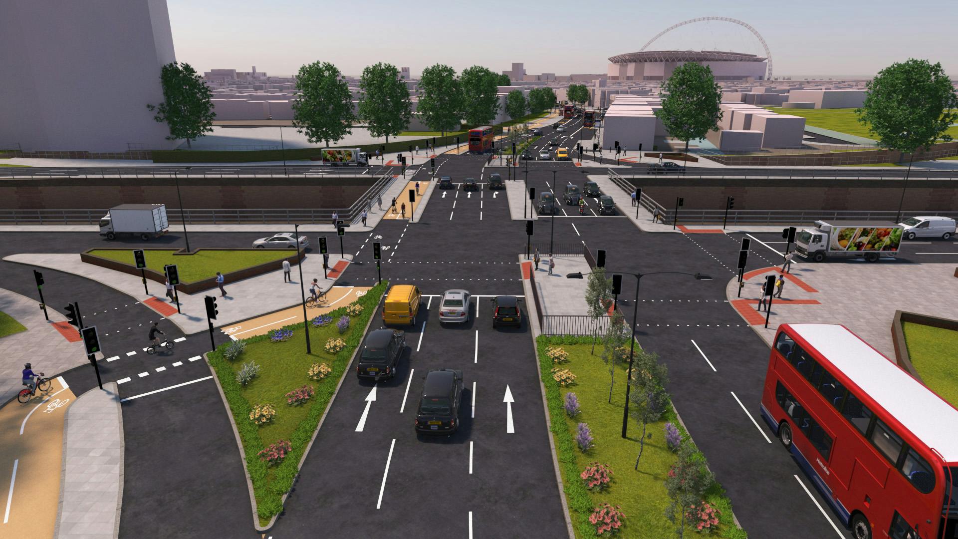
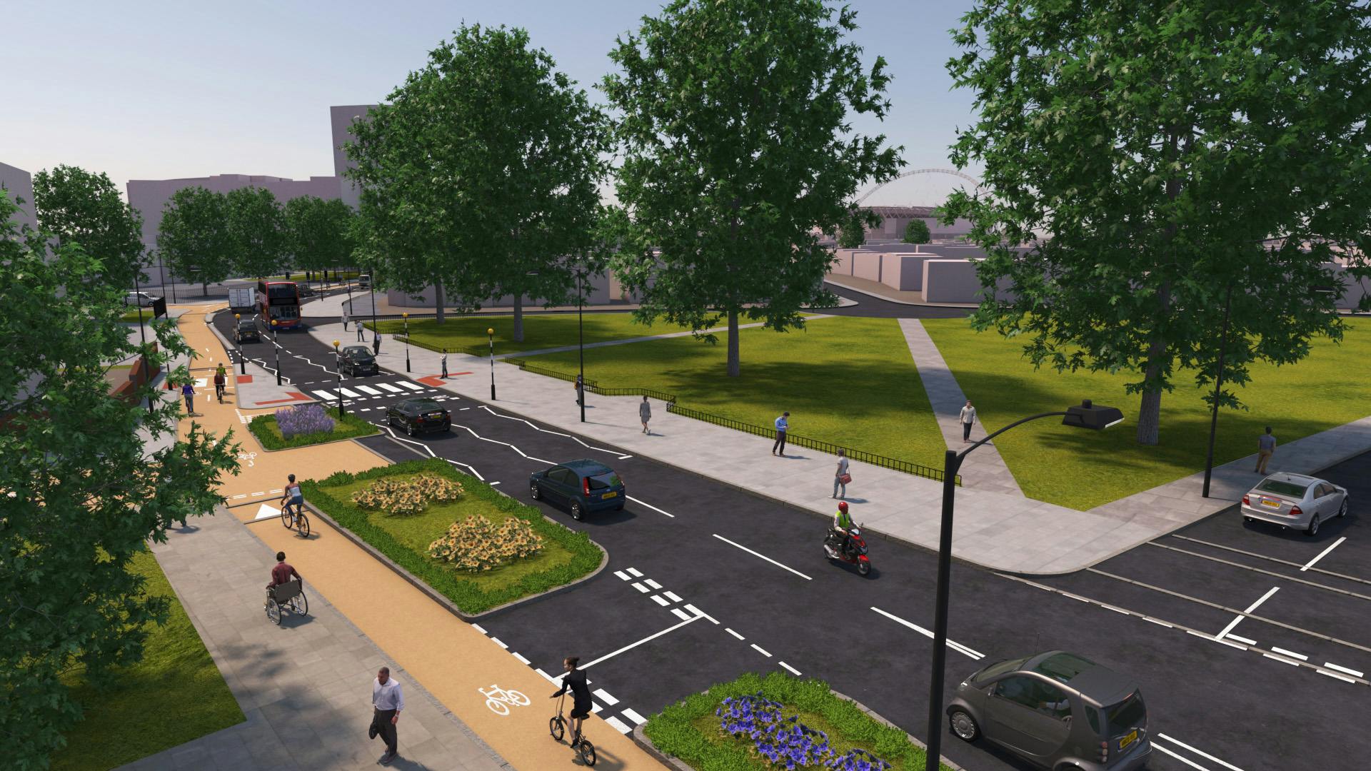
The proposals include a protected two-way cycle lane on the A404 Harrow Road and Brentfield, new and improved cycle and pedestrian crossings over Harrow Road, better street lighting to help make the area feel safer and more trees and plants more welcoming.
This would help us to reduce air pollution and carbon emissions, which could improve local people’s health. It would also address congestion, and help support new developments planned across the wider area by providing better walking and cycling links to local businesses and stations.
Find out more about the background to our proposals.
What are the proposals?

The changes we would like to make are:
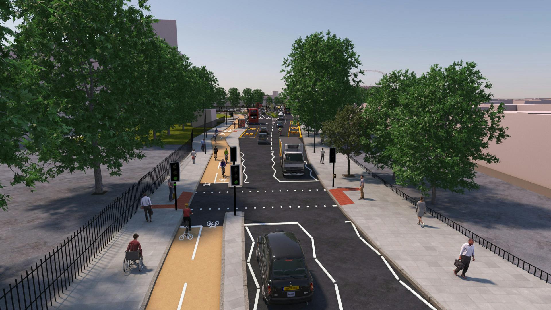
- Introducing a new protected two-way cycle lane on the A404 Harrow Road and Brentfield between Sylvia Gardens and First Drive, with separate low level cycle signals at junctions, new cycle crossings and better connections to other local cycle routes
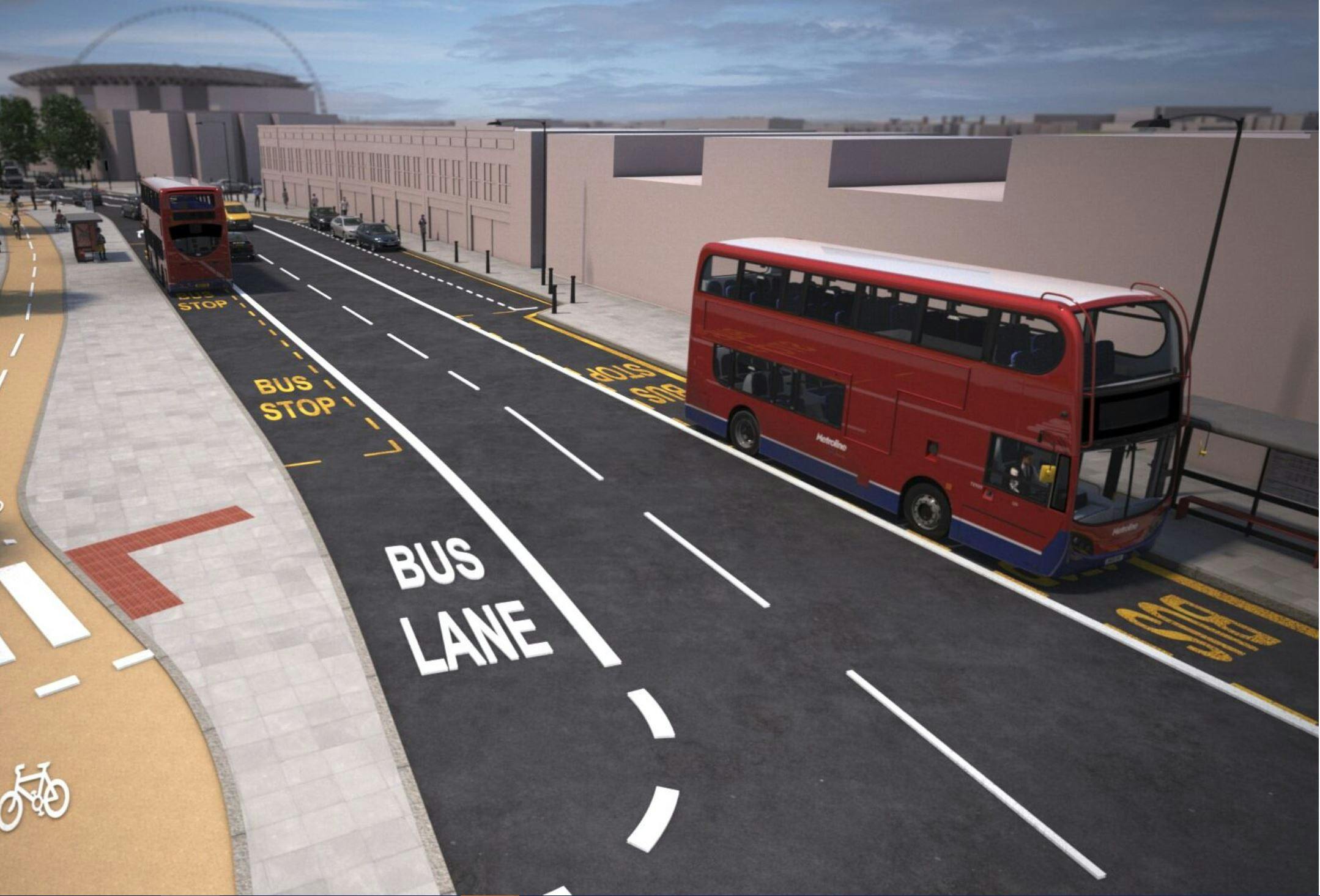
- Introducing bus stop bypasses for cyclists at bus stops C and K, with the two-way cycle lane behind the bus stop island for cyclist safety
- Improving the quiet road cycle connections to Wembley Central and Harlesden stations
- Improving the route for pedestrians by adding a new crossing over Brentfield near Bridge Park Community Leisure Centre and making existing crossings at the A406 junction more direct, which will reduce crossing times
- We’ll add measures to slow traffic speeds, add better street lighting and drainage, and new areas of planting and trees where space allows along the route
- Improving the service for bus passengers by extending bus stop D so two buses can stop here at a time, and moving stop B in line with the traffic lane so that buses can pull away easily after passengers board
- Other changes to allow us to make these improvements include closing the left turn filter lanes from the A406 onto Harrow Road and Brentfield, making Sylvia Gardens exit only for motor vehicles (currently entrance only), shortening a parking bay on Harrow Road and reviewing parking restrictions on the quiet road connections. We would also move bus stop ‘Sunny Crescent’ 90m to the eastern side of Wyborne Way to make space for the new cycle lanes
To read about the changes we plan to make in more detail, please see summary of changes page.
How you can find out more
We would like to know what you think about our proposals. The information below is available to help you respond:
- Summary of changes
- Overview maps of our proposals
- Detailed maps of our proposals
- Images of how our proposals may look if built
- A video showing the changes to the Harrow Road and Brentfield section of the scheme
- Frequently Asked Questions
- A copy of our consultation survey in case you would prefer to respond offline
- Easy Read versions of our proposals and survey
- Audio versions of the proposals and survey
- Healthy Streets checks for our proposals
If you need to translate this page into another language, please use the ‘Select language’ button at the bottom of this page.
Drop-in events
We will be holding two in person drop-in events at Bridge Park Community Leisure Centre, Brentfield, Harrow Road, London NW10 ORG on:
- Saturday 9 December (10:00 - 14:00)
- Tuesday 12 December (15:00 - 19:00)
These will give you an opportunity to get further information about the proposals and provide your thoughts and feedback, to allow us to consider your views.
Equalities Impact Assessment
Our Equality Impact Assessment (EqIA) identifies:
- The affects these proposals could have on people
- How we propose to minimise any negative impacts
After we’ve considered all comments, the EqIA will be reviewed and may be updated.
We use the EqIA to help us decide if, and how, we should proceed with these proposals.
Connecting with London's deaf community on our consultations
British Sign Language videos of the proposals and survey are available.
To further enhance how we engage and consult with London's deaf community we are trialling a British Sign Language (BSL) consultation conversation service for this consultation. This service will allow the TfL consultation lead to have a two-way BSL translated discussion on any aspect of this consultation with a BSL speaker.
To request a BSL consultation conversation please contact us at haveyoursay@tfl.gov.uk and we will be in contact to arrange this at a convenient time. Following this trial, we will evaluate the service to determine if this is something we are able to offer on other consultations in the future.
What happens next
These proposals are subject to the outcome of our consultation. Once consultation ends on 21 December 2023, we will spend time considering all the responses we receive and will prepare a consultation report.
The report will be available to everyone that takes part in the consultation and a copy will be published on our website.
-
Background to our proposals
Share Background to our proposals on Facebook Share Background to our proposals on X (formerly Twitter) Share Background to our proposals on Linkedin Email Background to our proposals linkConsultation has concluded Larger image
London’s population has changed dramatically over the past century and it will continue to change and grow in future. By 2031 there will be around 1.25 million more people living in London and over 750,000 new jobs. Many of the new homes that are built won’t have car parking facilities - there simply isn’t room in London for so many additional cars.Our vision for the route between Wembley Central and Harlesden stations is that it should be much less dominated by motor traffic and be a much less intimidating place to be for everyone.
There is a strong case for less motor traffic and more space for walking and cycling along the route. The number of people who will be walking and cycling in London is set to continue to grow in future, and we expect that the number of people cycling in the Wembley and Harlesden area will grow too.
We want to make the route safer and more comfortable for vulnerable road users, including pedestrians and cyclists. We’ve been talking to local people about our plans since January 2020 and we’ve reflected on these discussions in developing the proposals that we are now consulting you on.
Our proposals are in line with our Vision Zero strategy, which aims to eradicate deaths and serious injuries from our roads. The proposals have been designed according to our Healthy Streets approach, which aims to make London a safer, healthier and greener place to live and travel.
-
Summary of changes between Wembley Central and Harlesden Stations
Share Summary of changes between Wembley Central and Harlesden Stations on Facebook Share Summary of changes between Wembley Central and Harlesden Stations on X (formerly Twitter) Share Summary of changes between Wembley Central and Harlesden Stations on Linkedin Email Summary of changes between Wembley Central and Harlesden Stations linkConsultation has concludedOn this page we list the changes we are proposing to make between Wembley Central and Harlesden stations.
Maps of our proposals
Improvements for cyclists
Improvements for pedestrians
Changes for bus users
Other changes to support the improvements
Changes to the Harrow Road and Brentfield section of the scheme
The video shows the proposed changes on the Harrow Road and Brentfield section of the scheme where many of the most significant changes will be made to help you understand our proposals better.
Improvements for cyclists
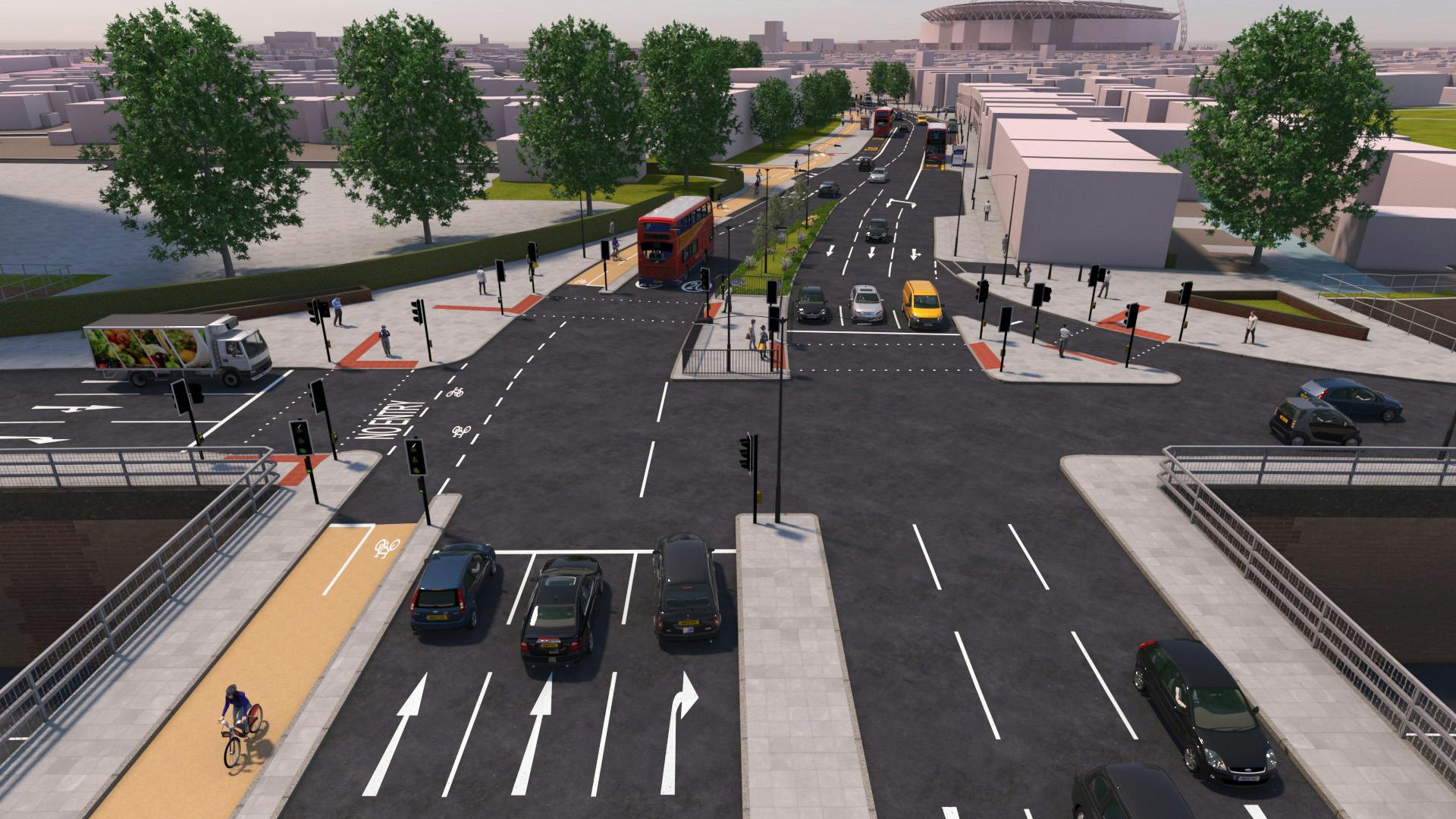
- A two-way protected cycle lane (separating cyclists from general traffic with a kerb) on the A404 Harrow Road and Brentfield between Sylvia Gardens and First Drive
- We’ll have separate low-level signals for cyclists at the proposed new pedestrian crossing on Brentfield by the leisure centre and at the A406 junction with Brentfield and Harrow Road, so it’s clear when they can pull ahead
- Existing crossings upgraded so cyclists can also use them to cross Harrow Road at Monk’s Park and First Drive including areas where there is shared use footway
- Bus stop bypasses introduced for cyclists at bus stops C and K, with the two-way cycle lane behind the bus stop island for cyclist safety
- The cycleway will link to existing London Cycle Network routes (LCN45 and LCN85) making cycling journeys to neighbouring areas easier
- Improved way finding to help cyclists along the cycleway including on quiet road connections to Wembley Central and Harlesden stations
- Shelley Road junctions with Milton Avenue and Mordaunt Road amended to give priority to the cycle route, with give way lines added to instruct drivers to give way to cyclists
- Cycle parking and storage to be reviewed along the cycleway route and increased where needed at the next stage of the project
- At Wembley Brook, we'll use special mirrors to help drivers and cyclists see each other more easily
Improvements for pedestrians
- New push button green man crossing over the Brentfield A404 by Bridge Park Community Leisure Centre
- The pedestrian crossings at Harrow Road junction with the A406 will be made simpler and more direct with one fewer stage to cross
- New zebra crossing at Brentfield near its junction with First Drive
- There will be new raised tables at most side road junctions between Wembley and Harlesden to make pedestrians and cyclists more visible and traffic slow down
- We're reviewing street lighting to make sure it's easy to see at night, and we're planning to provide new ‘rain gardens’ where space allows which will help reduce the chance of local flooding. If there's enough space, we’ll add new trees where we can
Changes for bus users
- We would extend bus stop D on A404 Harrow Road by 12 metres so two buses can stop at the same time, this will help the bus service be faster
- We would move bus stop B ‘Stonebridge Park Station’ in line with the traffic lane so buses can pull away more easily
- We're moving bus stops K and C onto bus stop islands and creating bus stop bypasses, with the cycle lane behind them to help avoid collisions between cyclists and bus riders
- At stop C the cycleway will be at the back of the footway, with all pedestrian movements using the front of the footway via a zebra crossing over the cycleway
- Bus stop ‘Sunny Crescent’ by the children’s playground (served by routes 18 and N18) to be moved 90m to the eastern side of Wyborne Way so that it is opposite the Cycle King Factory and the Hillside Centre, to make space for the new cycleway and crossing improvements
- We'll extend the bus lane on Harrow Road by 25 metres on the south-bound side into the A406 junction, and take away a 20 metre section of bus lane on Brentfield on the north-bound side to help traffic flow through the A406 junction. All other bus lanes in the area will operate as normal
Other changes to support the improvements
- We're closing the two filter lanes for traffic to turn left from the A406 into Harrow Road and Brentfield. This would give pedestrians more space and make the crossings safer and easier to use
- Traffic can still turn left at the junction in both cases which will be increased to three lanes, but it will be easier for pedestrians to cross here
- Sylvia Gardens (currently entrance only from Harrow Road) will become exit only to reduce the risk of collisions. Cyclists can still use it in both directions
- We're making more room for buses at bus stop D by making a parking bay on A404 Harrow Road outside Stonebridge Park shops smaller by 12 metres
- We're extending the 20mph speed limit on Harrow Road to east of Point Place, and adding traffic calming measures along the quiet road connections at Albert Terrace, Milton Avenue, Mordaunt Road, London Road, Tokyngton Avenue and Sylvia Gardens
- We'll make sure all road users have clear lines of sight along the quiet road connections to Wembley Central and Harlesden Stations by adding new yellow line parking restrictions where needed (please see maps)
- We’ll review the existing layout of the cycle lane next to the footway along Wembley Brook and will consider changing this space to a shared use footway to make sure it is as user friendly as possible for pedestrians and all types of cycles
Overview maps and detailed maps showing the proposed changes are available.
-
Maps of our proposals
Share Maps of our proposals on Facebook Share Maps of our proposals on X (formerly Twitter) Share Maps of our proposals on Linkedin Email Maps of our proposals linkConsultation has concludedOn this page you can find maps showing the changes we are proposing to make between Wembley Central and Harlesden stations. The route has been split into three sections. Click on the maps to view larger versions.
1. Wembley Central to Sylvia Gardens overview maps
 Wembley Central to Sylvia Gardens part 1
 Wembley Central to Sylvia Gardens part 2
Wembley Central to Sylvia Gardens detailed mapsYou can find more detailed maps of the proposals by clicking on the links below.
Wembley Central to London Road
Tokyngton Avenue Wembley Brook
Tokyngton Avenue Bovington Avenue
Tokyngton Avenue Sylvia Gardens
2. Harrow Road to Brentfield overview maps
Harrow Road to Brentfield detailed mapsYou can find more detailed maps of the proposals by clicking on the links below.
3. First Drive to Harlesden station overview map FIrst Drive to Harlesden station
First Drive to Harlesden station detailed mapsYou can find more detailed maps of the proposals by clicking on the links below.
First Drive to Stonebridge Park
Stonebridge Park and Albert Terrace
Albert Terrace and Milton Avenue
Shelley Road and Mordaunt Road
-
Healthy Streets
Share Healthy Streets on Facebook Share Healthy Streets on X (formerly Twitter) Share Healthy Streets on Linkedin Email Healthy Streets linkConsultation has concluded Larger image
The proposals for this scheme have been designed according to our Healthy Streets approach, which aims to make London a safer, healthier and greener place to live and travel.
The assessments below show how the different sections of the scheme meet our Healthy Streets indicators.
Harrow Road 1 of 3 Monks Place to Points Place
Harrow Road 2 of 3 Points Place to Conduit Way
Harrow Road 3 of 3 Conduit Way to First Drive
A404 High Road to east of the junction with Cecil Avenue
London Road to Tokyngton Avenue
Gaddesden Avenue to Sylvia Gardens
Tokyngton Avenue to Harrow Road
First Drive to Stonebridge Park
Albert Terrace to Shelley Road


Custom

Images of our proposals

Videos
-
 British Sign Language (BSL) video
-
 British Sign Language (BSL) video
-
 Proposed changes on the Harrow Road and Brentfield section of the scheme
