

Woolwich Ferry to Plumstead walking and cycling changes
Consultation has concluded
Update 26 July 2024
We are now able to publish our report on the outcomes of our public consultation on proposals to extend Cycleway 4 from Woolwich Ferry towards Plumstead.
We received 438 responses to the consultation and would like to thank everyone who took part. Having considered all the feedback carefully we have decided to proceed with our proposals, with the following changes:
- We are no longer proposing to build out the pavement on the south side of Powis Street between John Wilson Street and Hare Street
- We now intend to provide a ‘straight across’ pedestrian crossing over the A206 instead of a staggered crossing. This will simplify the crossing by removing the number of crossing movements pedestrians will need to make
- We are not proposing changes to the junction of the A206 Beresford Road and Burrage Road at this stage, however we will continue to review the location alongside Royal Borough of Greenwich and private landowners to identify future opportunities to further improve pedestrian and cycling facilities
- At the junction of the A206 and Maxey Road we will extend the proposed set back between the cycleway and carriageway to provide adequate space for vehicles turning into and out of Maxey Road and reduce possible conflict between vehicles and cyclists
We are aiming to begin work on this scheme during the 2025-26 financial year and further communications with the public will take place in due course.
-update ends-
Update 26 February 2024
This consultation has now closed. Thank you to everyone who responded. We are analysing your feedback and will report back shortly.
-update ends-
 Junction at A206/ Woolwich New RoadOn this page you can read how we are proposing to improve walking, cycling and road safety between Woolwich and Plumstead and how you can have your say.
The consultation is open until Sunday 25 February 2024 to give us your feedback.
Summary of changes
Impact of proposals on bus journey times and general traffic
Background
How you can find out more
Tell us your views
Equalities Impact Assessment
What happens next
What are the proposals?

The changes we would like to make include:
Cycling improvements
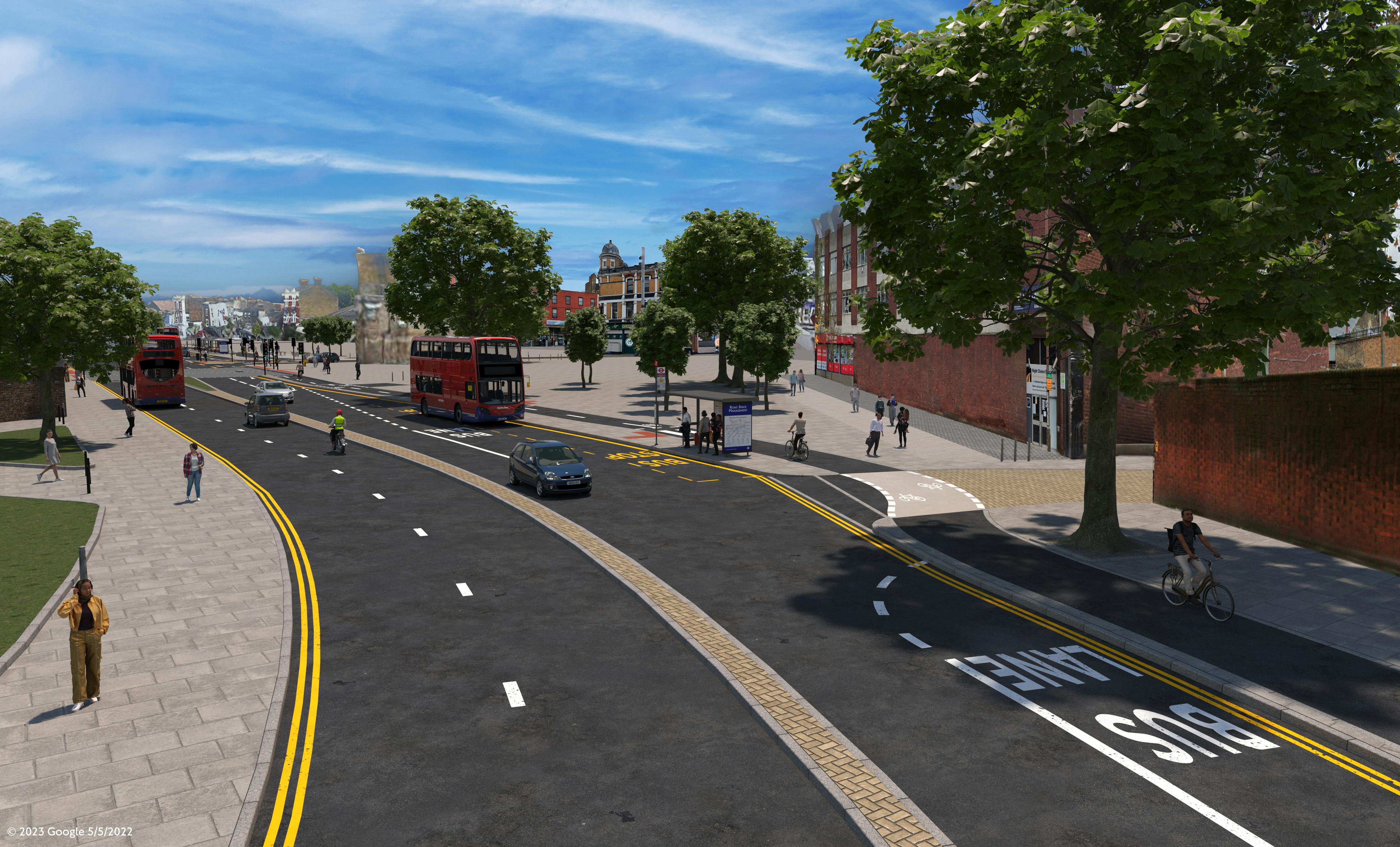
- New two-way segregated cycle track along the southern side of Beresford Street
- New westbound segregated cycle lane between Maxey Road and Burrage Road, connecting into the existing westbound segregated cycle lane to the east of Maxey Road
- Advisory cycle lanes introduced on Macbean Street, which is a low trafficked street
- Cycling to be permitted on Powis Street between Bernard Close and Macbean Street
Pedestrian improvements
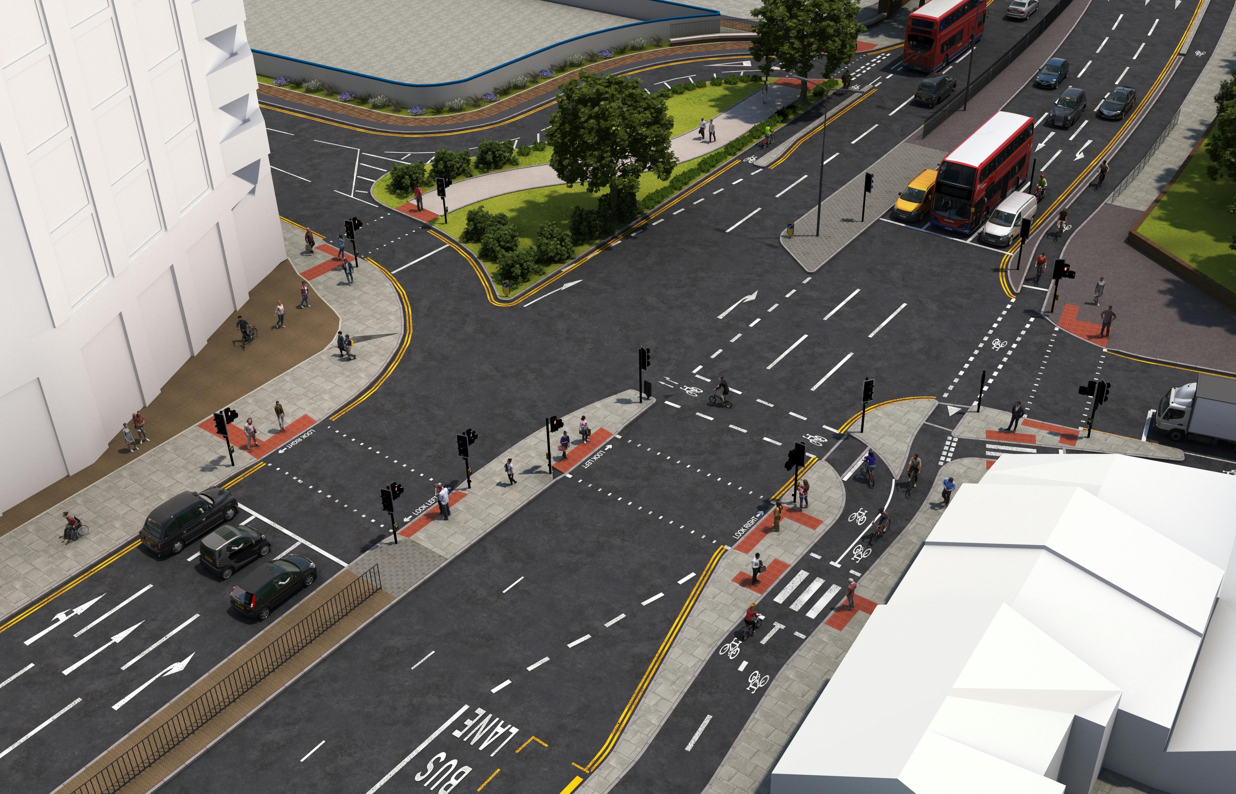
- New signalised pedestrian crossing over the eastern arm of the A206/ Woolwich New Road junction
Bus improvements
- New westbound bus lane on Beresford Street and Woolwich High Street between Macbean Street and Woolwich Ferry Roundabout
- Remove bus stop C on Woolwich High Street and replace with a bus stand. Routes 51, 99 and 386 would start their service from bus stop F on Hare Street
- Convert bus stop U Beresford Square/ Woolwich Arsenal Station, Z Woolwich, D Woolwich Station and ZA Plumstead Road/ Burrage Road to a bus stop bypass. A bus stop bypass involves routing the cycle track behind the bus passenger boarding area to maintain the separation of people cycling from motor traffic. These are an important safety feature of segregated cycle routes
To read about the changes we plan to make in more detail, please see our summary of changes page.
Background
We have been working closely with the Royal Borough of Greenwich since 2018 to develop projects that would make it safer and easier for local people to walk and cycle. This consultation proposes a series of improvements between Woolwich Ferry roundabout and Plumstead.
In summary, we’re proposing to extend the existing cycling facilities east from Woolwich Ferry roundabout towards Plumstead, to end at the junction of Plumstead Road with Maxey Road. From Woolwich Ferry roundabout, the new cycle lane would run southeast along Powis Street onto Macbean Street and then east along the A206 Beresford Street, terminating at Plumstead Road. We’re also proposing a series of improvements for pedestrians throughout the area, and to introduce new bus lanes along Beresford Street and Woolwich High Street.
We have published a series of maps to illustrate the changes we propose, together with artists impressions to show how these changes might look once built. We have also published a document which describes the changes we propose to make in more detail.
The changes we propose would make streets in the area safer, helping meet our Vision Zero target, as well as being more pleasant by enabling people to walk and cycle more. Our proposals would help us to reduce air pollution and carbon emissions, which could improve local people’s health. It would also address congestion and help support new developments planned across the wider area by providing better walking and cycling links to local businesses and stations.
How you can find out more
We would like to know what you think about our proposals. The information below is available to help you respond:
- Overview map of our proposals
- Detailed map of our proposals
- Images of how our proposals may look if built
- Frequently Asked Questions about the scheme
- A copy of our consultation survey in case you would prefer to respond offline
- Easy Read versions of our proposals and survey
- Audio versions of the proposals and survey
- Healthy Streets checks for our proposals
If you need to translate this page into another language, please use the ‘Select language’ button at the bottom of this page.
Public drop-in event
We will be holding an engagement event for those who wish to speak with staff directly, as follows:
Thursday 8 February 2024 (14:00 – 19:00)
Woolwich (Elizabeth line) station, Dial Arch Square, Major Draper Street, Woolwich, SE18 6GD
These will give you an opportunity to get further information about the proposals and provide your thoughts and feedback, to allow us to consider your views.
Equalities Impact Assessment
Our Equality Impact Assessment (EqIA) identifies:
- The affects these proposals could have on people
- How we propose to minimise any negative impacts
After we’ve considered all comments, the EqIA will be reviewed and may be updated.
We use the EqIA to help us decide if, and how, we should proceed with these proposals.
Connecting with London's deaf community on our consultations
British Sign Language videos of the proposals and survey are available.
To further enhance how we engage and consult with London's deaf community we are trialling a British Sign Language (BSL) consultation conversation service for this consultation. This service will allow the TfL consultation lead to have a two-way BSL translated discussion on any aspect of this consultation with a BSL user.
To request a BSL consultation conversation please contact us at haveyoursay@tfl.gov.uk and we will be in contact to arrange this at a convenient time. Following this trial, we will evaluate the service to determine if this is something we are able to offer on other consultations in the future.
What happens next
These proposals are subject to the outcome of our consultation. Once consultation ends on Sunday 25 February 2024, we will spend time considering all the responses we receive and will prepare a consultation report.
The report will be available to everyone that takes part in the consultation and a copy will be published on our website.
-
Summary of changes
Share Summary of changes on Facebook Share Summary of changes on X (formerly Twitter) Share Summary of changes on Linkedin Email Summary of changes linkConsultation has concludedWe propose to make the following key changes between Woolwich and Plumstead. We have described the changes we propose in sections. We have also published a series of maps to help illustrate the changes we propose to make.
Powis Street and Macbean Street
Junction of Beresford Street (A206) / Macbean Street
Woolwich High Street and Beresford Street between the Woolwich Ferry roundabout and Macbean Street
Beresford Street between the junction with Macbean Street to the junction with Woolwich New Road
Junction of Beresford Street / Woolwich New Road
Plumstead Road between the junction with Woolwich New Road and Maxey Road
Junction of Plumstead Road / Burrage Road
Powis Street and Macbean Street
- Footway widened on the southern side of Powis Street to provide more space for pedestrians
- Continuing the footway over the accesses to Travelodge and Powis Street car parks, to give priority to pedestrians
- Allowing cyclists to use Powis Street between Bernard Close and Macbean Street, supported by road markings
- Allowing contraflow cycling on Macbean Street between Powis Street and Creton Street, supported by road markings
- Change to waiting restrictions on Macbean Street from single yellow to double yellow
- New cycle lanes introduced on Macbean Street, which tends to be used by fewer vehicles
We’re also exploring whether it might be possible to introduce new ‘rain gardens’ on the northern side of Powis Street (these are marked on the map as ‘low level planting’). Rain gardens provide environmental and drainage benefits by capturing rainfall and filtering runoff from the highway and footway. They act like a giant sponge by storing and cleaning rainwater before it reaches the sewer system. This also reduces the risk of flooding.
We would coordinate any works to build these changes with the Royal Borough of Greenwich’s public realm improvements along Powis Street, as part of their Future High Streets Fund scheme.
Junction of Beresford Street (A206) / Macbean Street
 Link section east of A206/ Macbean Street (Click on image for larger version)
- Footway build out on the north-east and southern corners of the Beresford Street (A206) / Macbean Street junction to reduce pedestrian crossing distances and provide wider footways for a shared pedestrian and cycle space
- A new ‘parallel’ cycle crossing would replace the existing shared use crossing over Macbean Street
- The northbound cycle lane on Macbean Street would be raised to footway level at the junction. The cycle lane would be indicated by a low level kerb between the footway and cycle lane, to raise awareness of the facility to pedestrians. The footway would be reduced slightly to 1.8 metres adjacent to the traffic signal pole over a distance of approximately 3 metres, but remains 2 metres and wider elsewhere
- The existing shared cycle and pedestrian crossings are retained over Beresford Street and New Warren Lane, to assist cyclists to and from developments to the north
Woolwich High Street and Beresford Street between the Woolwich Ferry roundabout and Macbean Street
- Remove two existing bus stand spaces from Beresford Street and relocate them to Woolwich High Street. The existing bus stand on Woolwich High Street would be extended to accommodate the relocated stand spaces
- Remove bus stop C on Woolwich High Street and replace it with a bus stand. Routes 51, 99 and 386 would start their service from bus stop F on Hare Street
- New eastbound bus stop for route 301 on Beresford Street. The eastbound route 301 would start its service from this stop
- New westbound bus lane on Beresford Street and Woolwich High Street between Macbean Street and Woolwich Ferry Roundabout
Beresford Street between the junction with Macbean Street to the junction with Woolwich New Road
- New two-way segregated cycle track along the southern side of Beresford Street
- The cycle track is raised to footway level to the west of the bus stop U. The cycle track will be indicated by a low level kerb, between the footway and cycle track, to raise awareness of the facility to pedestrians
- Changes to the central ‘median’ in the highway, to create space for the new cycle track
- Relocate the existing bus stands to the outside of the cycle track
- Convert bus stop U Beresford Square – Woolwich Arsenal Station to a ‘bus stop bypass
- Continue footway surfacing across accesses to improve pedestrian priority
- Reduce the width of the footway in order to provide space for the two-way cycle track. Footway reduces to 1.9 metres in two locations over a distance of 6.5 metres and 17.5 metres at bus stop U but remains 2 metres and wider elsewhere
We would coordinate any works to build these changes with the Royal Borough of Greenwich’s public realm improvements along Beresford Square, as part of their Future High Streets Fund scheme.
Junction of Beresford Street / Woolwich New Road
- New signalised pedestrian crossing over the eastern arm of the A206/ Woolwich New Road junction
- Relocate the western section of the pedestrian ‘super crossing’ c.15 metres east towards the centre of the junction. This would help to improve junction efficiency, and reduce the network impact of introducing the new crossing over the eastern arm
- New dedicated cycle signals so cyclists can proceed through the junction whilst other motor traffic is held on a red signal
- Remove four trees to support the introduction of the new pedestrian crossing. We’ve indicated on the maps we’ve published which trees would be removed. We will look to replace trees elsewhere along the route (subject to further surveys and investigations)
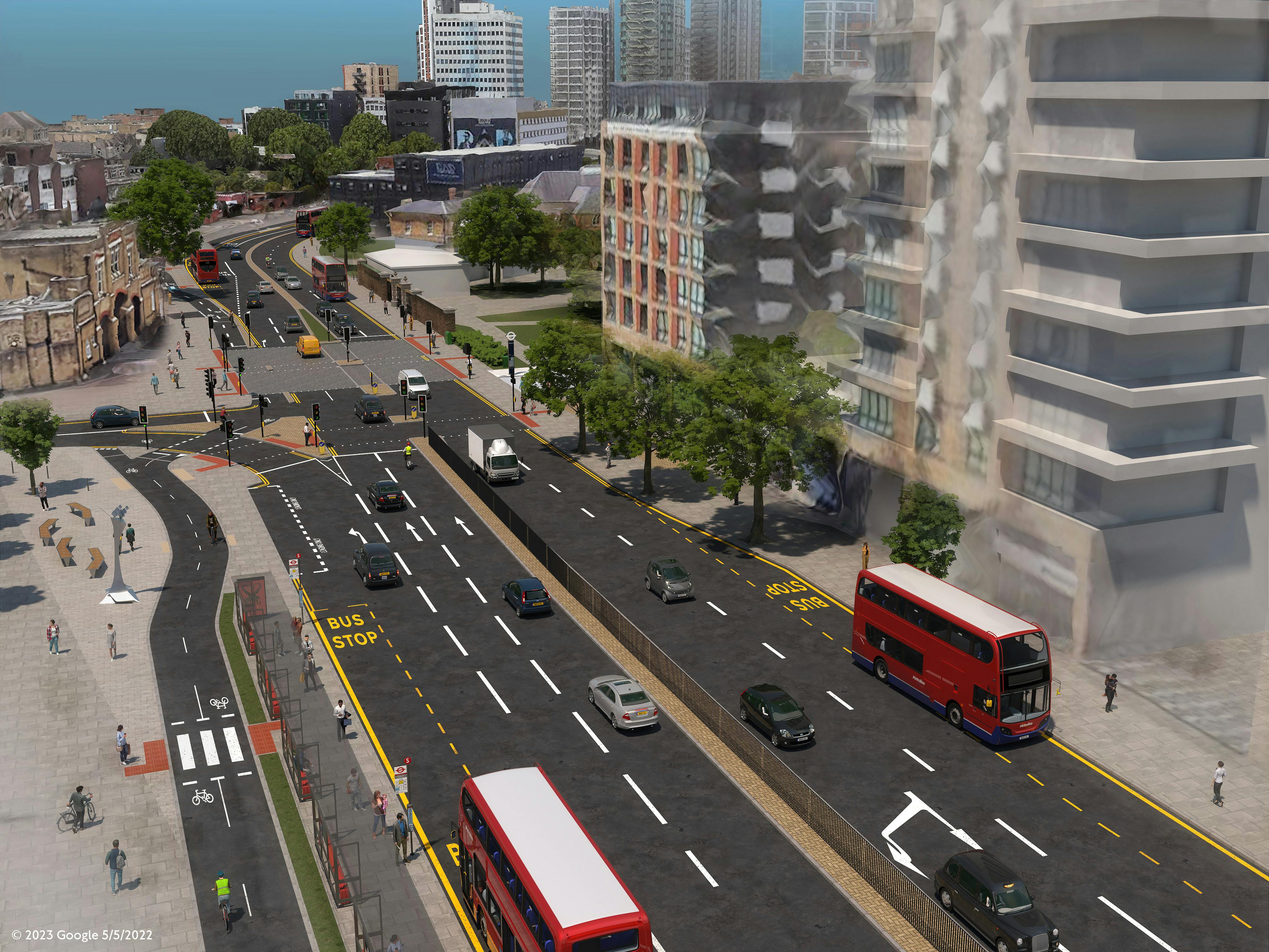
Plumstead Road between the junction with Woolwich New Road and Maxey Road
- New two-way segregated cycle track on the southern side of the A206 raised to footway level. The cycle track will be indicated by a low-level kerb between the footway and cycle track, to raise awareness of the facility to pedestrians
- Convert bus stop Z Woolwich and D Woolwich Station to a bus stop bypass
- Relocate the existing loading bay to the outside of the cycle track. A 2.5 metres footway would be provided between the loading bay and the cycle track, and dropped kerbs provided to help people to cross the track
- Removal of four trees, and planting of two new trees providing suitable planting locations can be identified. We have identified which trees we propose to remove on the maps we have published. We will look to plant further trees elsewhere along the route (subject to further surveys)
- Loading bay removed between Parry Place and Burrage Road to create space for a new signalised cycle crossing
- Convert bus stop ZA Plumstead Road/ Burrage Road to a bus stop bypass
- The Royal Borough of Greenwich is investigating opportunities for a taxi bay near to the Elizabeth Line station. We will continue to work closely with Officers to support this ongoing work
Junction of Plumstead Road / Burrage Road
- Dedicated cycle signals to allow eastbound cyclists to leave the two-way cycle track and join the existing eastbound cycle lane whilst other traffic is held on a red signal
- New parallel cycle crossing on Burrage Road to allow westbound cyclists to cross the side road and join the two-way cycle track
- Existing pedestrian crossing island made wider
- New northbound cycle lane on Burrage Road on the immediate approach to the junction to help cyclists join the two-way cycle track
- New westbound segregated cycle lane between Maxey Road and Burrage Road, connecting into the existing westbound segregated cycle lane to the east of Maxey Road


Custom


Document library
-
 Easy read proposals (669 KB) (pdf)
-
Easy read survey (250 KB) (pdf)
-
Equality Impact Assessment (EqIA) (1.63 MB) (pdf)
-
Consultation survey (245 KB) (pdf)
-
Healthy Streets check (694 KB) (pdf)
-
 Word versions
-
Woolwich Ferry to Plumstead walking and cycling changes report.docx (8.84 MB) (docx)
-
Woolwich Ferry to Plumstead walking and cycling changes report.pdf (2.26 MB) (pdf)

Image library
Audio files
BSL videos
-
 British Sign Language (BSL) video
-
 British Sign Language (BSL) video
