West London Orbital

Share West London Orbital on Facebook Share West London Orbital on X (formerly Twitter) Share West London Orbital on Linkedin Email West London Orbital link
Help shape the future of transport in West London by sharing your views on our proposal for a new West London Orbital rail service.


The line would form a new part of the London Overground and is intended to make travelling around the west of London more convenient.

Please use the buttons below to find out more about our plans, including the route, new stations, our plans for the existing stations and how the proposals may impact you and your local area. You can also find out how to ask questions and find further information, including in accessible formats.

The feedback you give will help us decide how to develop our proposals further, and understand and respond to issues that are raised.

The consultation will be open until 18 November 2026.

Why a West London Orbital?


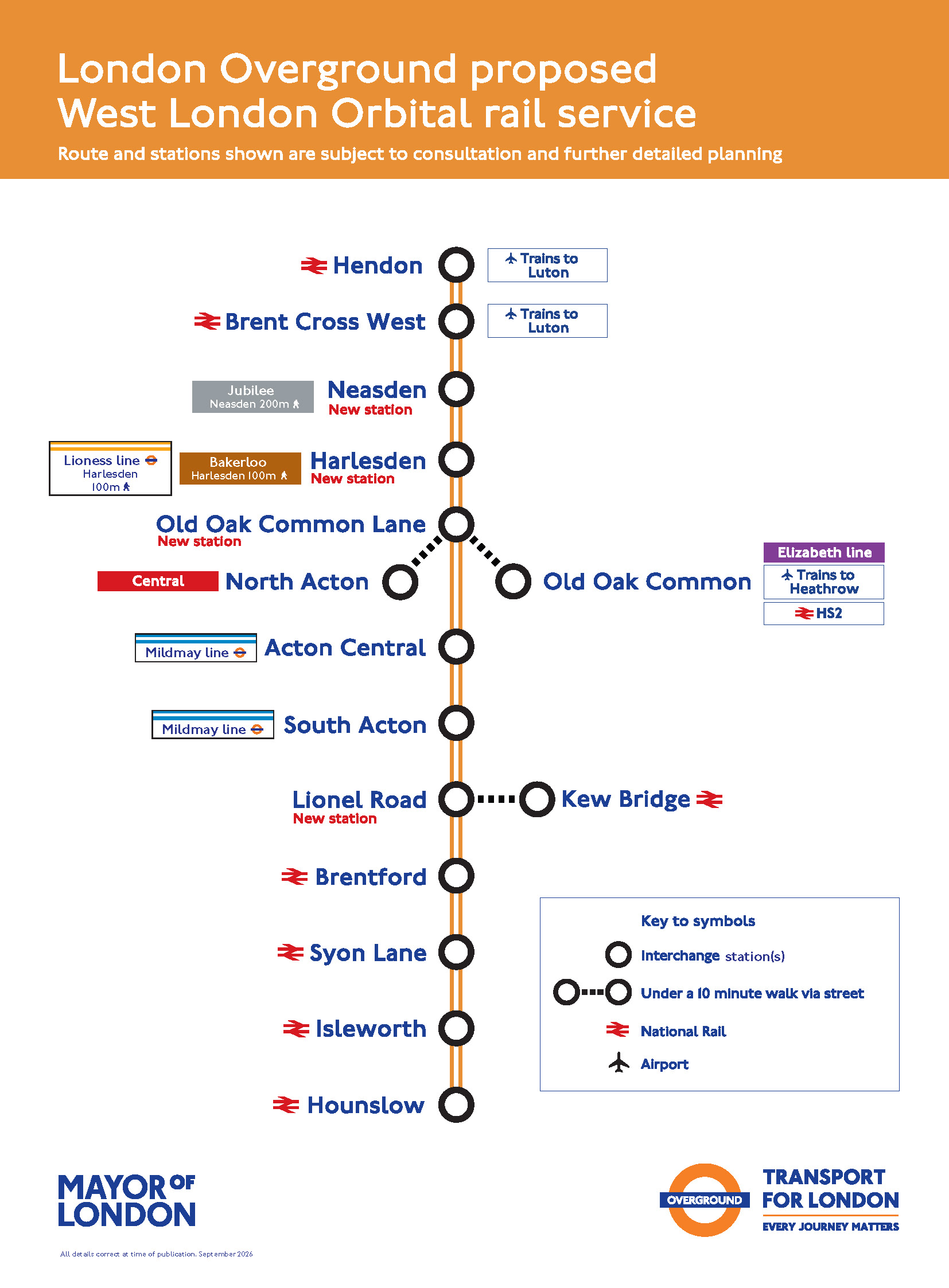
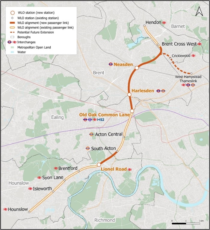
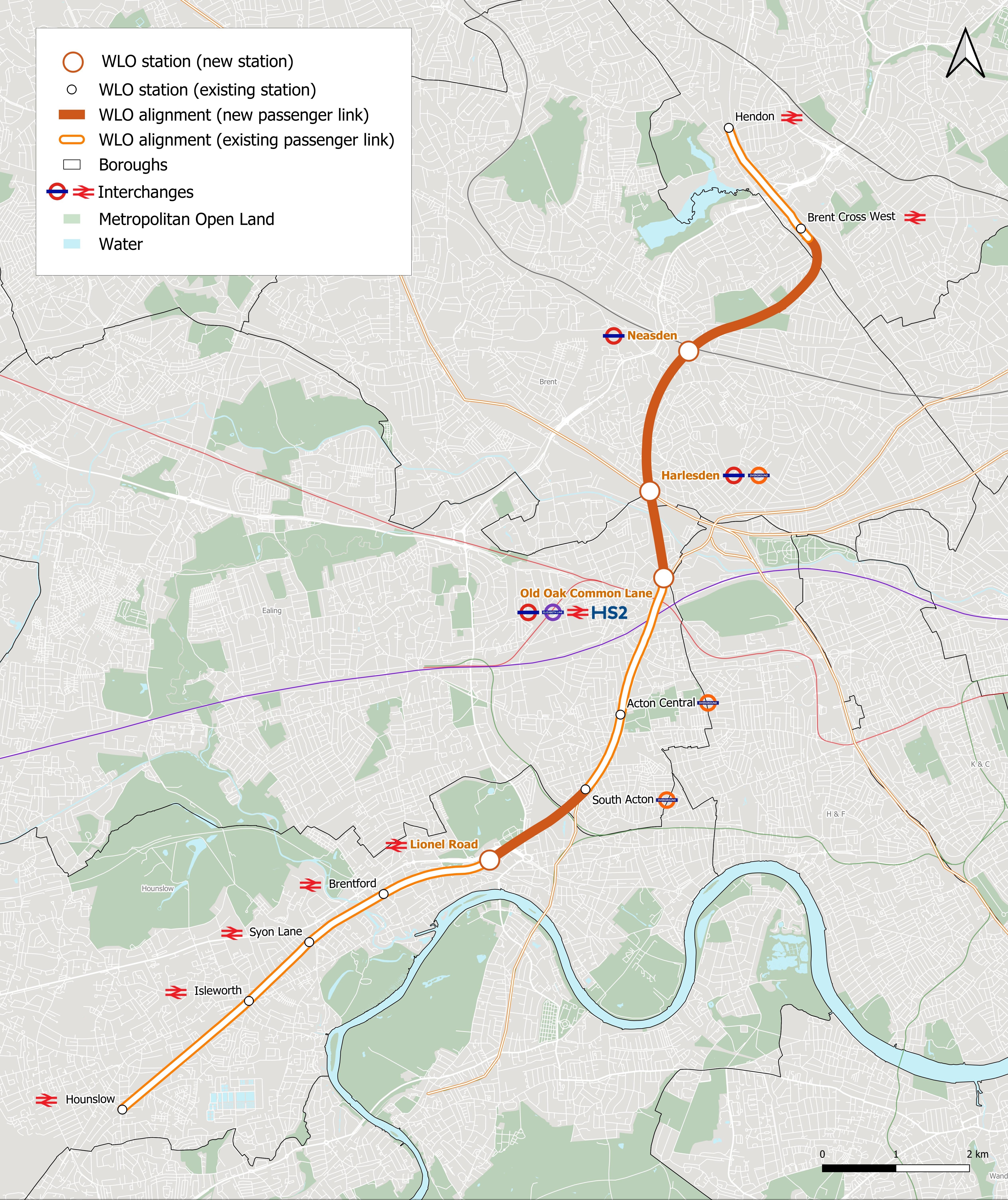
We’re developing proposals for a new rail service, the West London Orbital (WLO). It would be a new London Overground service. It is proposed to run between Hounslow and Hendon, making use of existing rail lines that are currently underused - including the Dudding Hill line, which is currently only used by freight services.

The service would serve a mix of new stations and upgrades to current ones. The proposed new stations are:

  • Neasden

  • Harlesden

  • Old Oak Common Lane

  • Lionel Road

Some existing stations would need new platforms, entrances or other upgrades to support the WLO service. You can read more about the new stations by using the 'Stations' button above.

You can read more about the proposed route and why we chose it by using the 'Route' button above.

This new service has the potential to make travelling across west and northwest London much easier. We’re looking for your views to help shape these proposals.

Why is it called the "Orbital"?

The WLO would run around London rather than straight into the centre, forming a kind of arc through west and northwest London. This orbital route makes it quicker and easier to travel between outer London areas without changing in central London.


What would the WLO do?


Improve connections across West London
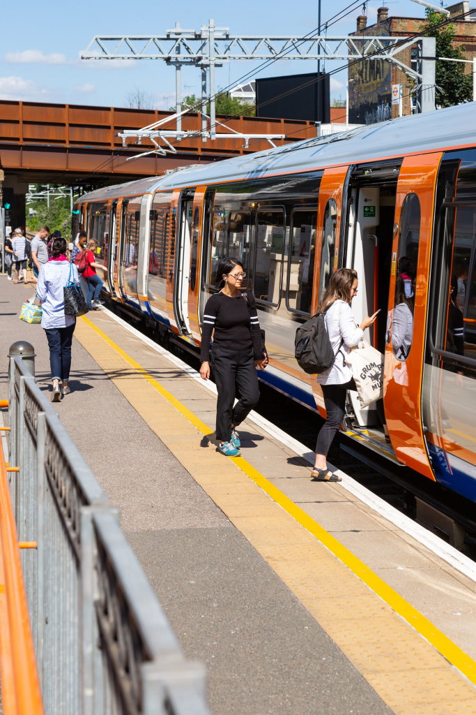

Parts of west London don’t currently have convenient rail links or attractive alternatives to car use. The WLO would change this by creating new direct services between key town centres and growing places - including Opportunity Areas, which are parts of London identified in the Mayor’s current London Plan as having significant potential for new homes, jobs and infrastructure. Opportunity Areas that could significantly benefit from the WLO include:

  • Old Oak and Park Royal

  • Brent Cross and Cricklewood

  • Wembley

  • Burnt Oak and Colindale

  • Heathrow

  • Great West Corridor

This means more efficient, active and sustainable travel options for local and growing communities.


Support new homes and jobs


Improved public transport helps unlock new homes and employment opportunities. The WLO has been designed to support planned growth across the area, connecting people to new housing, workplaces and town centres.


Improve transport capacity


As London’s population and economy grow, the transport network needs to grow too. The WLO would give people more frequent services and travel choices, provide increased accessibility, relieve pressure on busy rail and road routes, and improve the resilience of the wider network.


Provide environmental and social benefits


The WLO aims to:

  • Provide better public transport which could help cut road emissions by providing an alternative to car journeys, supporting net zero and climate change ambitions

  • Improve access to jobs, education and local facilities such as healthcare

  • Provide better connections for communities that currently have fewer sustainable transport options

  • Improve access to leisure and cultural opportunities

  • Improve local environmental quality

These benefits support a healthier, greener and fairer west London.

You can read more about the business case for the scheme here.

How these proposals were developed

We’ve designed the route to make good use of existing rail corridors. This helps reduce disruption, keep construction impacts low and ensure good value for money.

We’ve been working closely with the London Boroughs of Barnet, Brent, Ealing and Hounslow, the West London Alliance and the Old Oak and Park Royal Development Corporation on these proposals, as well as Network Rail and other development partners.

This consultation is designed to help us understand whether the WLO proposals meet the needs of local communities, gather feedback on potential stations and the proposed route, and identify issues we need to explore further as designs develop. Your views will help shape the next phase of work. There will be more opportunities to comment through future public consultations and engagement as the project progresses.

Return to the top of the page
Help shape the future of transport in West London by sharing your views on our proposal for a new West London Orbital rail service.


The line would form a new part of the London Overground and is intended to make travelling around the west of London more convenient.

Please use the buttons below to find out more about our plans, including the route, new stations, our plans for the existing stations and how the proposals may impact you and your local area. You can also find out how to ask questions and find further information, including in accessible formats.

The feedback you give will help us decide how to develop our proposals further, and understand and respond to issues that are raised.

The consultation will be open until 18 November 2026.

Why a West London Orbital?


We’re developing proposals for a new rail service, the West London Orbital (WLO). It would be a new London Overground service. It is proposed to run between Hounslow and Hendon, making use of existing rail lines that are currently underused - including the Dudding Hill line, which is currently only used by freight services.

The service would serve a mix of new stations and upgrades to current ones. The proposed new stations are:

  • Neasden

  • Harlesden

  • Old Oak Common Lane

  • Lionel Road

Some existing stations would need new platforms, entrances or other upgrades to support the WLO service. You can read more about the new stations by using the 'Stations' button above.

You can read more about the proposed route and why we chose it by using the 'Route' button above.

This new service has the potential to make travelling across west and northwest London much easier. We’re looking for your views to help shape these proposals.

Why is it called the "Orbital"?

The WLO would run around London rather than straight into the centre, forming a kind of arc through west and northwest London. This orbital route makes it quicker and easier to travel between outer London areas without changing in central London.


What would the WLO do?


Improve connections across West London


Parts of west London don’t currently have convenient rail links or attractive alternatives to car use. The WLO would change this by creating new direct services between key town centres and growing places - including Opportunity Areas, which are parts of London identified in the Mayor’s current London Plan as having significant potential for new homes, jobs and infrastructure. Opportunity Areas that could significantly benefit from the WLO include:

  • Old Oak and Park Royal

  • Brent Cross and Cricklewood

  • Wembley

  • Burnt Oak and Colindale

  • Heathrow

  • Great West Corridor

This means more efficient, active and sustainable travel options for local and growing communities.


Support new homes and jobs


Improved public transport helps unlock new homes and employment opportunities. The WLO has been designed to support planned growth across the area, connecting people to new housing, workplaces and town centres.


Improve transport capacity


As London’s population and economy grow, the transport network needs to grow too. The WLO would give people more frequent services and travel choices, provide increased accessibility, relieve pressure on busy rail and road routes, and improve the resilience of the wider network.


Provide environmental and social benefits


The WLO aims to:

  • Provide better public transport which could help cut road emissions by providing an alternative to car journeys, supporting net zero and climate change ambitions

  • Improve access to jobs, education and local facilities such as healthcare

  • Provide better connections for communities that currently have fewer sustainable transport options

  • Improve access to leisure and cultural opportunities

  • Improve local environmental quality

These benefits support a healthier, greener and fairer west London.

You can read more about the business case for the scheme here.

How these proposals were developed

We’ve designed the route to make good use of existing rail corridors. This helps reduce disruption, keep construction impacts low and ensure good value for money.

We’ve been working closely with the London Boroughs of Barnet, Brent, Ealing and Hounslow, the West London Alliance and the Old Oak and Park Royal Development Corporation on these proposals, as well as Network Rail and other development partners.

This consultation is designed to help us understand whether the WLO proposals meet the needs of local communities, gather feedback on potential stations and the proposed route, and identify issues we need to explore further as designs develop. Your views will help shape the next phase of work. There will be more opportunities to comment through future public consultations and engagement as the project progresses.

Return to the top of the page
  • Drop-in events

    Share Drop-in events on Facebook Share Drop-in events on X (formerly Twitter) Share Drop-in events on Linkedin Email Drop-in events link

    We will be holding drop-in events on the following dates where you can find out more about our proposals:

    Saturday 3 October 2026 (11.00 - 14.00)
    Old Isleworthians’ Association Sports Club, 22A Wood Lane, Isleworth TW7 5ED

    Saturday 10 October 2026 (12.00 - 15.00)
    Harlesden Library, Craven Park Road, London NW10 8SE

    Tuesday 13 October 2026 (16.00 - 19.00)
    Chiswick Works, 100 Bollo Lane, London W4 5LX

    Saturday 17 October 2026 (11.00 - 14.00)
    Oaklands Social, Oaklands House, Old Oak Common Lane, London NW10 8DU

    Monday 19 October 2026 (16.00 - 19.00)
    Mitchell Brook Primary School, Bridge Road, London NW10 9BX

    Thursday 22 October 2026 (16.00 - 19.00)
    Water and Steam Museum, Green Dragon Lane, Brentford TW8 0EN

    Saturday 24 October 2026 (11.00 - 14.00)
    Act One Cinema, 119-121 Acton High Street, London W3 6NA

    Saturday 31 October 2026 (11.00 - 14.00)
    Claremont Park (Halloween Dog Parade event), Brent Cross Town, London NW2 1FE

    Tuesday 3 November 2026 (16.00 - 19.00)
    Brent Cross West Station, Geron Way, London NW2 6LW

    Thursday 5 November 2026 (12.00 - 15.00)
    Middlesex University (main quad), The Burroughs, London NW4 4BT

    Saturday 7 November 2026 (11.00 - 14.00)
    Hounslow House Library, 7 Bath Road, Hounslow TW3 3EB


    Return to main page

    We will be holding drop-in events on the following dates where you can find out more about our proposals:

    Saturday 3 October 2026 (11.00 - 14.00)
    Old Isleworthians’ Association Sports Club, 22A Wood Lane, Isleworth TW7 5ED

    Saturday 10 October 2026 (12.00 - 15.00)
    Harlesden Library, Craven Park Road, London NW10 8SE

    Tuesday 13 October 2026 (16.00 - 19.00)
    Chiswick Works, 100 Bollo Lane, London W4 5LX

    Saturday 17 October 2026 (11.00 - 14.00)
    Oaklands Social, Oaklands House, Old Oak Common Lane, London NW10 8DU

    Monday 19 October 2026 (16.00 - 19.00)
    Mitchell Brook Primary School, Bridge Road, London NW10 9BX

    Thursday 22 October 2026 (16.00 - 19.00)
    Water and Steam Museum, Green Dragon Lane, Brentford TW8 0EN

    Saturday 24 October 2026 (11.00 - 14.00)
    Act One Cinema, 119-121 Acton High Street, London W3 6NA

    Saturday 31 October 2026 (11.00 - 14.00)
    Claremont Park (Halloween Dog Parade event), Brent Cross Town, London NW2 1FE

    Tuesday 3 November 2026 (16.00 - 19.00)
    Brent Cross West Station, Geron Way, London NW2 6LW

    Thursday 5 November 2026 (12.00 - 15.00)
    Middlesex University (main quad), The Burroughs, London NW4 4BT

    Saturday 7 November 2026 (11.00 - 14.00)
    Hounslow House Library, 7 Bath Road, Hounslow TW3 3EB


    Return to main page

  • Route infrastructure

    Share Route infrastructure on Facebook Share Route infrastructure on X (formerly Twitter) Share Route infrastructure on Linkedin Email Route infrastructure link

    New infrastructure on the WLO route

    To deliver this new rail link safely and reliably, we would need to upgrade parts of the railway and build new infrastructure. We are also considering how the trains on the WLO might be powered, and what infrastructure might be needed to support this. These works may cause temporary impacts during construction, and we’re also carefully assessing how the project could affect the environment.

    Upgrades to the existing railway are essential to allow safe, reliable passenger services and the planned frequency of trains on the WLO route.


    Junction Upgrades


    Acton Wells Junction (Old Oak

    New infrastructure on the WLO route

    To deliver this new rail link safely and reliably, we would need to upgrade parts of the railway and build new infrastructure. We are also considering how the trains on the WLO might be powered, and what infrastructure might be needed to support this. These works may cause temporary impacts during construction, and we’re also carefully assessing how the project could affect the environment.

    Upgrades to the existing railway are essential to allow safe, reliable passenger services and the planned frequency of trains on the WLO route.


    Junction Upgrades


    Acton Wells Junction (Old Oak Common area)

    Acton Wells Junction is one of the biggest constraints on the route. To run WLO services alongside existing freight and passenger trains, we need to:

    • Increase the number of tracks from two to four
    • Build a new bridge over the Central line for the additional tracks

    Old Kew Junction (near proposed Lionel Road station)

    This junction would connect the WLO to the Hounslow Loop line. It is currently a single track and so trains can’t pass each other. We plan to add a second track so trains can pass each other in both directions.


    Turnback facilities


    Turnbacks are short sections of track off the main running lines that allow trains to leave passenger service, wait, and rejoin the route without blocking other trains.

    We need to create two new turnbacks and plan to do so by installing short sections of new track at the following locations:

    Hounslow station (west of the terminus)

    This new section of track would allow WLO trains to turn around without getting in the way of South Western Railway or freight services.

    West of Lionel Road new station

    This new section of track would allow trains to be taken out of service during disruption on the Hounslow Loop.


    Powering trains - Electrification


    Only part of the route is currently electrified - between Acton Wells junction and South Acton - and between Old Kew junction and Hounslow. We are assessing three options for powering trains on the rest of the route:

    • Full overhead electrification
    • Partial electrification with hybrid battery‑electric trains
    • Battery trains charged at end-of-line stations

    The decision depends on feasibility, benefits and costs for installing, maintaining and operating each option and how it would fit with the rest of the Overground network.

    Unless battery charging at both ends proves feasible, we expect to install overhead electrification between Old Oak Common and Hendon.

    Construction of the WLO would be managed so we can upgrade junctions, build new tracks and turnbacks, and install electrification while keeping disruption as low as possible for other rail services. More detailed information about specific environmental and construction impacts will be available as the design develops. There will be more opportunities to comment through future public consultations and engagement as the project progresses.


    Return to main page

  • Train preparation facility

    Share Train preparation facility on Facebook Share Train preparation facility on X (formerly Twitter) Share Train preparation facility on Linkedin Email Train preparation facility link
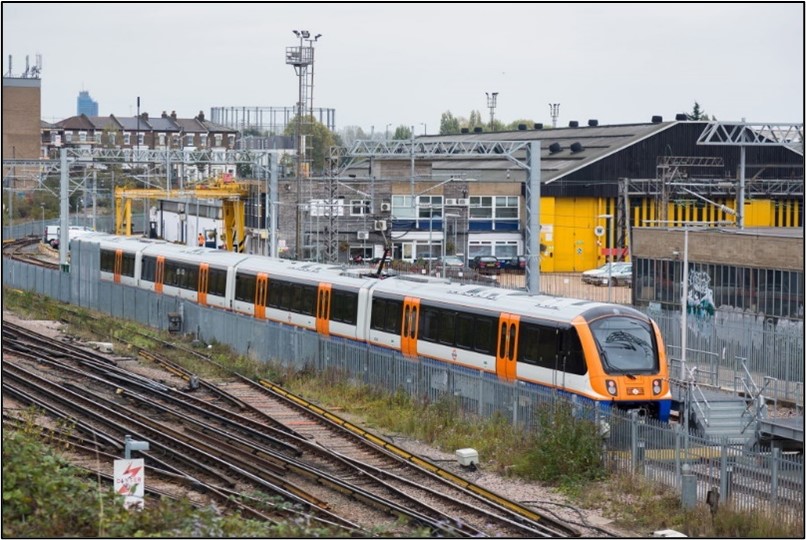
    photo of an Overground train in a depotTo run the new West London Orbital service, we expect to need 11 new London Overground trains.

    When these trains are not in service, they need to be stored, cleaned and prepared for the next day in a safe place.

    Because there is no extra space in existing London Overground depots or sidings, a new site for train preparation is needed close to the WLO route.


    What we look for in a preparation site


    To help us chose a location for train preparation, we looked for sites close to the WLO route so trains could start and finish their journeys

    photo of an Overground train in a depotTo run the new West London Orbital service, we expect to need 11 new London Overground trains.

    When these trains are not in service, they need to be stored, cleaned and prepared for the next day in a safe place.

    Because there is no extra space in existing London Overground depots or sidings, a new site for train preparation is needed close to the WLO route.


    What we look for in a preparation site


    To help us chose a location for train preparation, we looked for sites close to the WLO route so trains could start and finish their journeys easily. The sites also needed:

    • Enough space to hold all 11 trains

    • Good track connections so trains can enter and leave the site safely and without causing delays

    • Flexibility for other London Overground trains if needed in the future

    We looked at a wide range of possible locations. Our assessment showed that only one site meets the requirements.


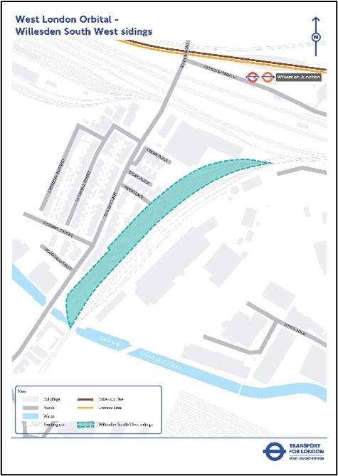
    Our Preferred site: Willesden South West Sidings


    Map of WLO Willesden South West sidingsClick on map for larger version Based on our assessment of options, Willesden South West Sidings, in the Old Oak Common area, is our preferred site for storing and preparing the WLO trains when not in service.

    The site could also work in combination with the existing London Overground preparation facility at Wembley, depending on how trains are organised across the network.

    About the site today:

    • It’s an existing railway site that’s currently disused

    • It’s owned by Network Rail and leased to a rail freight company

    • The layout and location make it suitable for storing and preparing the WLO fleet once it is upgraded


    How this fits with local development plans


    The Old Oak & Park Royal Development Corporation (OPDC) is leading a major regeneration programme in the area. Its Old Oak Masterplan aims to transform Old Oak over the coming years. OPDC has included Willesden South West sidings as a potential development site and we are working with them to ensure that both proposals will work together.

    Return to main page

  • Existing stations

    Share Existing stations on Facebook Share Existing stations on X (formerly Twitter) Share Existing stations on Linkedin Email Existing stations link

    Hendon Thameslink Station


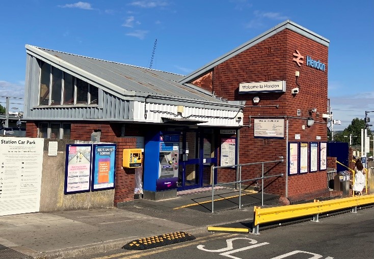
    Photograph of Hendon Thameslink stationWe would need to build two new platforms to serve the existing freight lines that run through the western side of the station. These platforms would be where WLO trains would terminate and start at the northern end of the route.

    To make this possible, we would also need to:

    • Make changes to the tracks and signals to allow freight trains to pass through while the other track is occupied by a WLO train

    • Build a new passenger footbridge to a provide step-free connection to the new and existing platforms

    We may need to take a small


    Hendon Thameslink Station


    Photograph of Hendon Thameslink stationWe would need to build two new platforms to serve the existing freight lines that run through the western side of the station. These platforms would be where WLO trains would terminate and start at the northern end of the route.

    To make this possible, we would also need to:

    • Make changes to the tracks and signals to allow freight trains to pass through while the other track is occupied by a WLO train

    • Build a new passenger footbridge to a provide step-free connection to the new and existing platforms

    We may need to take a small amount of land outside of the current railway boundary on the western side of the station to accommodate the proposed new platforms. We would aim to minimise any impacts on the local area if this should be the case.

    We are also considering options for a new second station entrance on the western side of the station that would connect to Irving Way.


    Brent Cross West Thameslink Station


    We will need to build two new platforms on the western side of the station to serve two of the existing freight lines. These new platforms would allow WLO services to stop at Brent Cross West station.

    We would also:

    • Build a new bridge which would connect to the existing station concourse providing a route to the WLO platforms
    • Add stairs and lifts for step free access to the WLO platforms

    During the construction of Brent Cross West station, future WLO platforms at the station were considered and works to assist with this were carried out during its construction, funded by Barnet Council. This was intended so that future modifications to Brent Cross West station would be easier to make and less impactful if the WLO were to go ahead.


    Acton Central Station


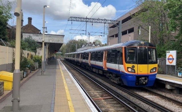
    a photo of an Overground train at Acton CentralIt is possible that the level crossing at Churchfield Road may need to close if the WLO was to go ahead, due to the increased frequency of trains with the new services. We may need to consider using the existing station subway as an unpaid route for non-station users to cross the railway.

    If we were to take forward this option:

    • Changes within the station would be needed

    • Ticket gates would still be provided, but in a different arrangement

    More information on possible changes at level crossings can be found here.


    South Acton Station


    We will be looking at options to improve step-free access at the station. Currently step-free access is available to each platform, but not between platforms within the station.

    No other significant changes are planned at the station.


    Brentford, Isleworth and Syon Lane Stations


    We are not proposing to make significant changes at these stations, as part of the WLO proposals. The stations would become fully staffed at all times while trains are running, providing benefits to station users.


    Hounslow Station


    As with South Acton, we will look at options to improve step-free access at the station. Currently step-free access is available to each platform, but not between platforms within the station.


    Return to main page


  • New stations

    Share New stations on Facebook Share New stations on X (formerly Twitter) Share New stations on Linkedin Email New stations link

    Four new stations are proposed as part of the WLO. Each station has been designed to improve local connections, support regeneration, and make it easier for people to travel across west and northwest London.

    The new stations are planned for:

    • Neasden

    • Harlesden

    • Old Oak Common Lane

    • Lional Road

    We know where we would like each new station to be located, but we still need to decide:

    • The exact layout

    • Access and interchange routes

    • How they connect to local streets

    We are also exploring what improvements to the street environment can be made around the new stations to ensure they fit

    Four new stations are proposed as part of the WLO. Each station has been designed to improve local connections, support regeneration, and make it easier for people to travel across west and northwest London.

    The new stations are planned for:

    • Neasden

    • Harlesden

    • Old Oak Common Lane

    • Lional Road

    We know where we would like each new station to be located, but we still need to decide:

    • The exact layout

    • Access and interchange routes

    • How they connect to local streets

    We are also exploring what improvements to the street environment can be made around the new stations to ensure they fit into the local area with easy to use and attractive routes to and from the stations.

    Why these stations?

    These locations were chosen because they support major growth areas, allow easy access to other rail and Tube services and would help support and connect new homes and jobs.


    Neasden Station


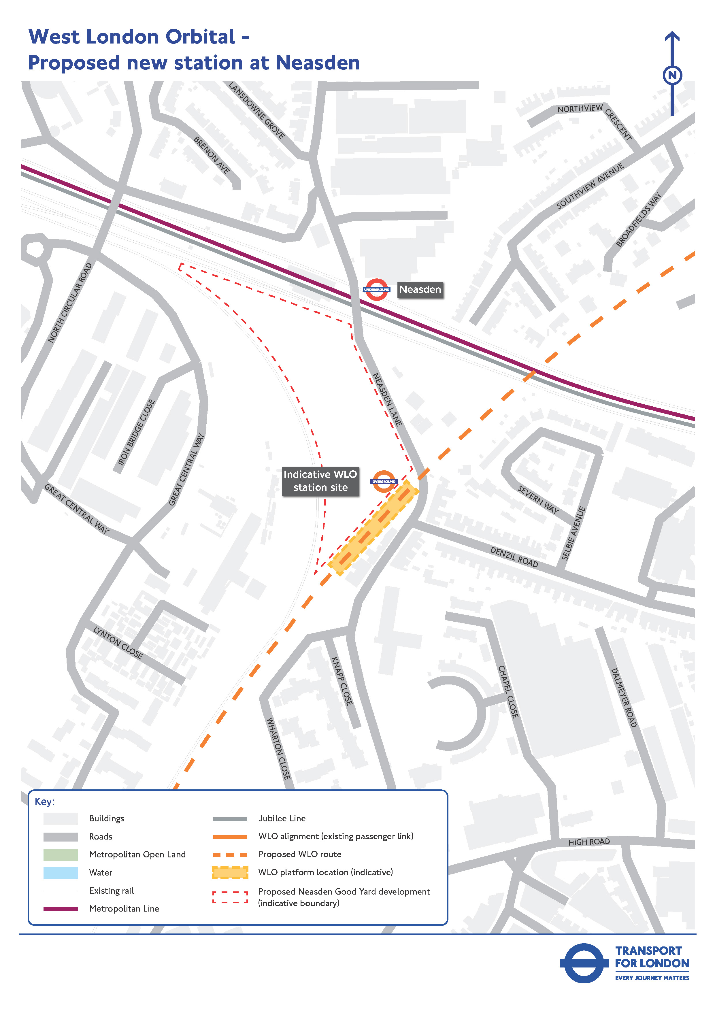
    The new WLO station at Neasden would be on Neasden Lane, about 200 metres south of the existing Neasden Underground station on the Jubilee line.

    This map shows the indicative proposed location of the new WLO station at Neasden:


    Diagram of location of a new station in Neasden(Click map for a larger version)

    Station layout and access

    • Platforms would be built on the existing embankment

    • Passengers would reach the platforms by stairs and lifts

    Interchange with Jubilee line services would be via:

    • A short walk along Neasden Lane, or

    • A new walking route through a planned development called Neasden Goods Yard

    Both the existing Underground station and the proposed WLO station sit within Brent Council’s Neasden Stations Growth Area Masterplan. This plan sets out a vision for major mixed use regeneration, including space for business and industrial uses, the potential for at least 2,000 new homes, and safeguards land within Neasden Goods Yard for the WLO station entrance.


    Harlesden Station


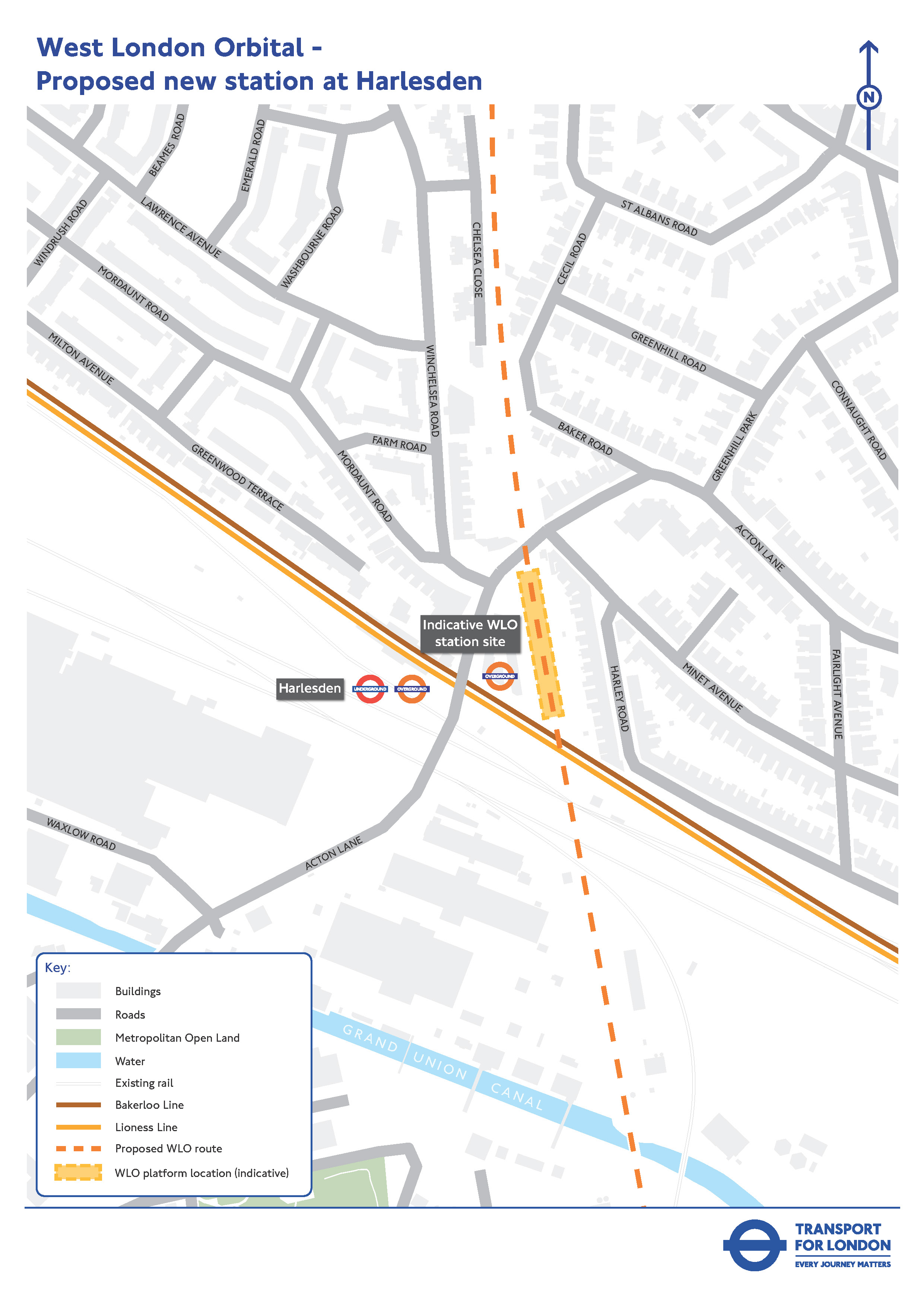
    The new station would be on Acton Lane, directly opposite the current Harlesden Underground station to allow easy street‑level interchange with the Bakerloo and Lioness lines.


    Map showing location of proposed new station in HarlesdenClick map for larger version

    Station layout and access

    • The station entrance would replace light industrial units currently on the site

    • Platforms would sit on an embankment

    • A new subway under the railway would link the entrance to both platforms

    • Stairs and lifts would provide step‑free access to platform level

    We are planning improvements to Acton Lane to ensure a safe, simple and accessible interchange. These may include wider pavements, new crossings, improved lighting, and clearer signage.

    The Old Sub Station building would be kept. The area between it and the new station would become new public space. Further to this consultation we will reach out to any affected property or landowners.


    Old Oak Common Lane Station


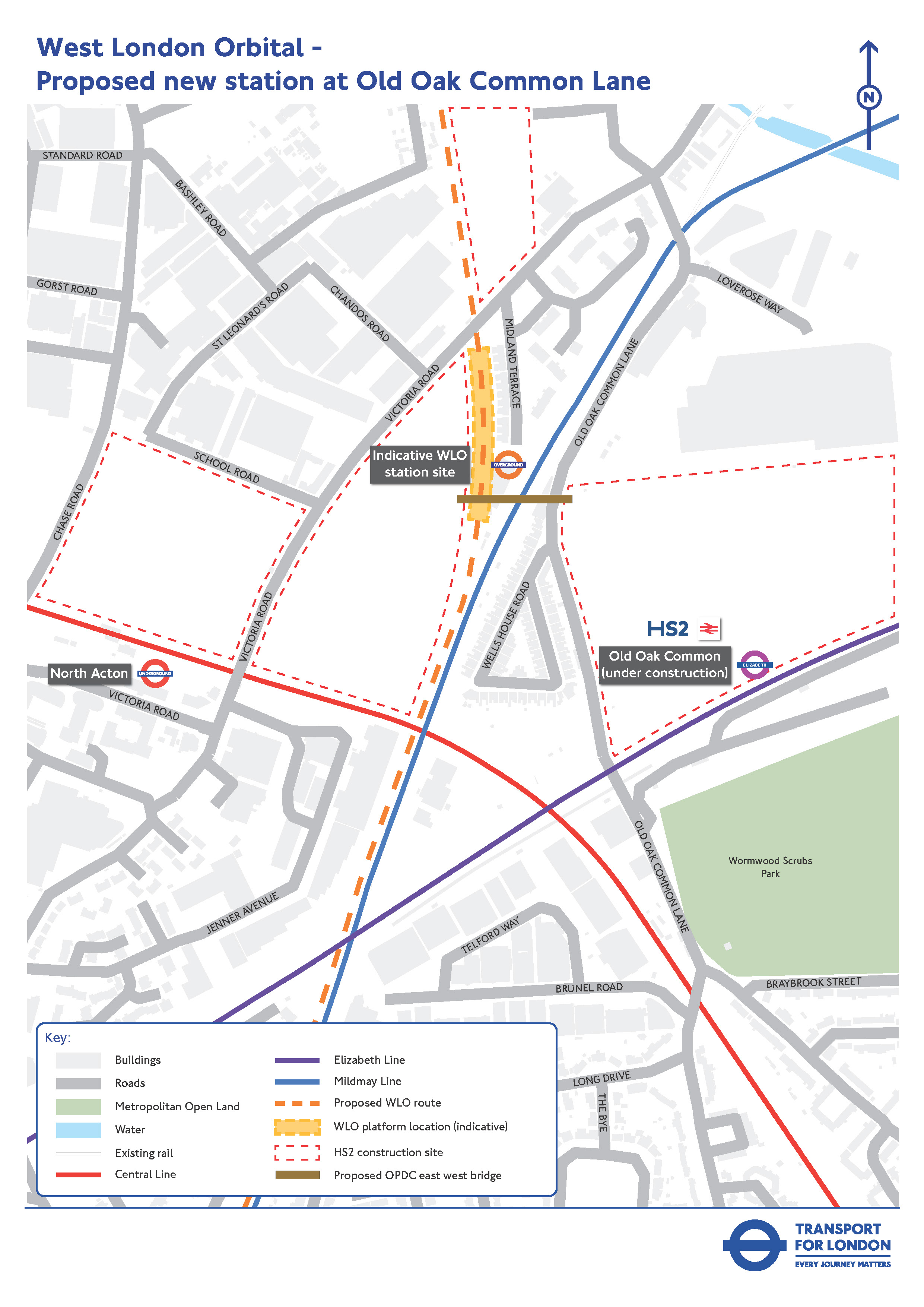
    A new station would be built between Victoria Road and Old Oak Common Lane. The station would be accessed from a new east-west pedestrian bridge being planned by the Old Oak and Park Royal Development Corporation. There would be three platforms for WLO services, including one platform to allow trains to turn back from the north.


    Map showing location of proposed new WLo station on Old Oak Common Lane(Click map for larger version)


    It would provide easy on‑street interchange with:

    • HS2, Elizabeth line and Great Western main line services at the new Old Oak Common multi-modal interchange hub station being provided by HS2 (approximately 400 metres, which is about a five to ten minute walk), and

    • Central line services at North Acton (approximately 500 metres, which is about a five to ten minute walk)

    Platforms on the Mildmay line could be built in the future at Old Oak Common Lane station, but this is not currently part of the WLO project and would need to be delivered separately.

    The station sits within the Old Oak and Park Royal Opportunity Area, one of London’s largest regeneration zones. The WLO, alongside HS2 and Elizabeth line services, would help support thousands of new homes, major new employment space, and an improved and better‑connected local transport network.


    Lionel Road Station


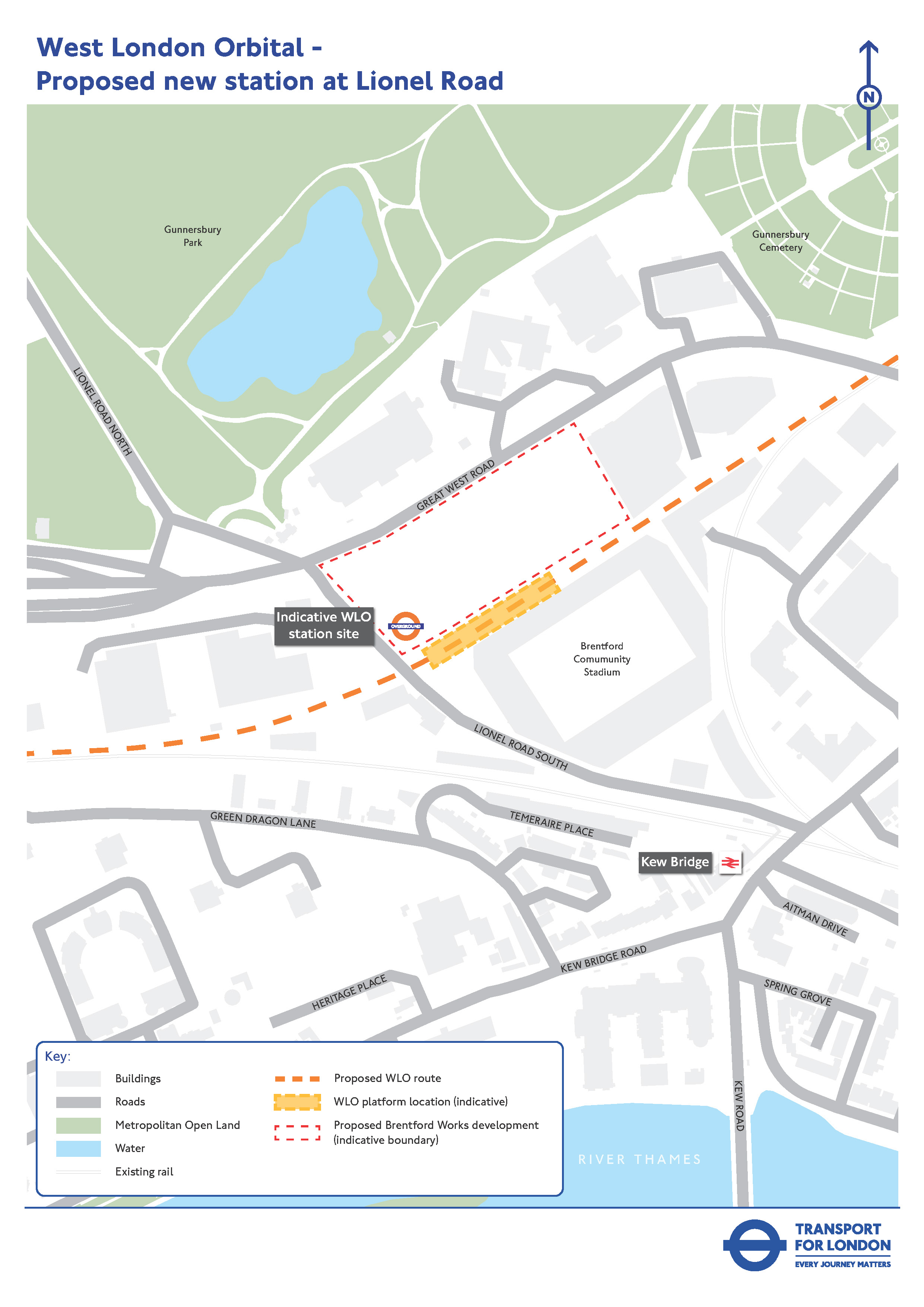
    Lionel Road would be a new station serving the growing area around the Great West Road and the new Brentford Community Stadium. The entrance to the station would be from Lionel Road South and from a station square planned to be delivered as part of the adjacent Brentford Works development. There would be two platforms, located between this development and the stadium.


    The station would be around 300 metres (a three to five minute walk) from Kew Bridge National Rail station, allowing on street interchange with South Western Railway services to and from London Waterloo and Surrey.


    Return to main page

  • Potential benefits

    Share Potential benefits on Facebook Share Potential benefits on X (formerly Twitter) Share Potential benefits on Linkedin Email Potential benefits link

    Easier interchange with other services


    The WLO would provide interchanges with the following stations and services:

    Hendon and Brent Cross West:

    • Thameslink services

    Neasden:

    • Jubilee line

    Harlesden:

    • Lioness line
    • Bakerloo line

    Old Oak Common Lane:

    • High Speed 2
    • Elizabeth line
    • Central line
    • Heathrow Express
    • Great Western Railway

    Lionel Road, Brentford, Syon Lane, Isleworth and Hounslow:

    • South Western Railway


    Reduced journey times


    The WLO would provide faster and more direct public transport journeys between key destinations across west and north-west London. For example:

    • 39 minute (57%) saving between Brentford and Neasden (29 minutes with WLO, compared

    Easier interchange with other services


    The WLO would provide interchanges with the following stations and services:

    Hendon and Brent Cross West:

    • Thameslink services

    Neasden:

    • Jubilee line

    Harlesden:

    • Lioness line
    • Bakerloo line

    Old Oak Common Lane:

    • High Speed 2
    • Elizabeth line
    • Central line
    • Heathrow Express
    • Great Western Railway

    Lionel Road, Brentford, Syon Lane, Isleworth and Hounslow:

    • South Western Railway


    Reduced journey times


    The WLO would provide faster and more direct public transport journeys between key destinations across west and north-west London. For example:

    • 39 minute (57%) saving between Brentford and Neasden (29 minutes with WLO, compared to 68 minutes without)

    • 17 minute (23%) saving between Brent Cross West and Heathrow Airport (57 minutes with WLO, compared to 74 minutes without)

    These faster and more convenient connections would make everyday trips easier for residents, workers and visitors. This includes improved access to jobs, for example nearly half a million extra people would be able to reach the new and existing jobs in the Old Oak Common area within an hour of travel time.

    Improved connections between employers, employees and suppliers would encourage greater investment in West London and support economic growth in areas such as film and TV, digital media, logistics and food manufacturing. Greater investment and economic confidence in an area will also encourage developers to deliver more new homes and at an accelerated pace.


    Access to key destinations


    As well as improving access to key town centres and essential community facilities such as GP surgeries, hospitals, libraries, parks and schools, the WLO would improve access by rail to some of London’s key leisure destinations such as:

    • Brent Cross Shopping Centre

    • Brentford FC’s Gtech community stadium

    • Wembley Stadium

    • Royal Botanic Gardens, Kew

    • Allianz stadium, Twickenham


    Accessibility


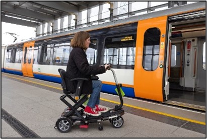
    Woman on mobility scooter boarding WLO train

    All the proposed new stations would have step-free access and new lifts would be provided on all platforms at Hendon, improving accessibility for people with reduced mobility, and those using pushchairs.

    The WLO would also provide more links to more destinations than the current network.


    Less crowded trains and improved reliability


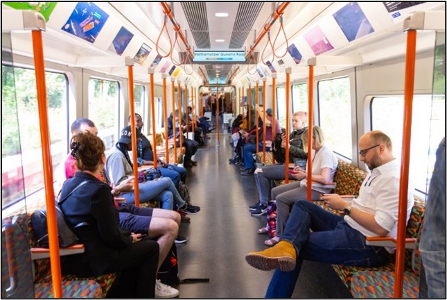
    Customers on a London Overground trainBy increasing capacity on the network, the WLO would help reduce crowding on rail, tube and bus services, improving conditions for many thousands of people every day.

    A number of people would no longer need to travel into Central London and back out to complete their journeys, which would contribute to reduced crowding on other key routes.

    It would also provide an additional alternative option during any service disruption, helping passengers avoid unexpected crowding on their journeys.

    The WLO would involve a number of upgrades to existing infrastructure which should improve reliability across the whole WLO corridor.


    Environmental benefits


    The WLO would contribute to an improved environment by providing a good quality alternative public transport option and reducing reliance on private car use. This could help reduce road congestion, carbon emissions and improve local air quality. It could also support better bus journeys and travel times. It would also provide opportunities for improving streetscape environments.


    Improved access to local town centres and businesses


    Town centres along the route would be more easily accessible, which could result in more footfall and business opportunities, including for smaller and independent businesses and busier high streets. This could also help people, including women and girls feel safer when visiting these areas.


    Return to main page

  • Impacts during construction & operation

    Share Impacts during construction & operation on Facebook Share Impacts during construction & operation on X (formerly Twitter) Share Impacts during construction & operation on Linkedin Email Impacts during construction & operation link

    During construction


    For people living close to the sites of the new stations or infrastructure there may be concerns about disruption during construction. For example, there may be increased noise and vibration during construction, and some trees and other vegetation may need to be removed to build new stations or other infrastructure.

    Local businesses close to new stations may also have concerns about their operations or reduced access to their premises during the construction period.


    During operation


    For residents and businesses close to the proposed route and new stations, the change from a lightly used freight route to a frequent


    During construction


    For people living close to the sites of the new stations or infrastructure there may be concerns about disruption during construction. For example, there may be increased noise and vibration during construction, and some trees and other vegetation may need to be removed to build new stations or other infrastructure.

    Local businesses close to new stations may also have concerns about their operations or reduced access to their premises during the construction period.


    During operation


    For residents and businesses close to the proposed route and new stations, the change from a lightly used freight route to a frequent passenger rail service may bring concerns about associated changes to factors such as noise, lighting and vibration. There would also be increased numbers of people accessing the local area to use the new stations, by foot, cycle, car or public transport which could lead to potential concern about noise and anti-social behaviour.

    We will have more information on potential construction and operation impacts as we develop our proposals at the next stage of design and these will be provided as part of a future consultation. We would seek to reduce and mitigate any impacts which cannot be avoided, so it is important that we hear about concerns about the impacts of the WLO proposals. Please take our survey to help us understand any issues relating to the proposals.


    Return to main page


  • Impacts on level crossings

    Share Impacts on level crossings on Facebook Share Impacts on level crossings on X (formerly Twitter) Share Impacts on level crossings on Linkedin Email Impacts on level crossings link

    You can find out more here about which crossings maybe affected, why the closures could be needed, the potential impacts from the closures and new access arrangements.


    Level Crossings – possible need for closures
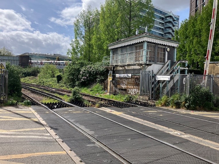

    A photograph of the Mildmay line level crossing and signal box at Bollo LaneWe may need to close three level crossings if the WLO were to go ahead:

    • Churchfield Road next to Acton Central station
    • Bollo Lane (Mildmay line) in South Acton

    • Wood Lane in Isleworth

    If the crossings need to close, we would ensure pedestrians and cyclists can still cross the railway at the same location or as nearby as possible, and that any closures are mitigated by

    You can find out more here about which crossings maybe affected, why the closures could be needed, the potential impacts from the closures and new access arrangements.


    Level Crossings – possible need for closures


    A photograph of the Mildmay line level crossing and signal box at Bollo LaneWe may need to close three level crossings if the WLO were to go ahead:

    • Churchfield Road next to Acton Central station
    • Bollo Lane (Mildmay line) in South Acton

    • Wood Lane in Isleworth

    If the crossings need to close, we would ensure pedestrians and cyclists can still cross the railway at the same location or as nearby as possible, and that any closures are mitigated by enhancements to active travel and the street environment.

    Should changes be required, this would provide an opportunity to reimagine these locations as safer, greener and better-connected places. Our aim would be not only to maintain convenient crossings for pedestrians and cyclists, but also to enhance the local environment through improved walking and cycling routes, public realm upgrades, new planting and measures that support thriving neighbourhoods and local businesses.

    This consultation presents an overview of the range of options that may be considered for these three locations as the WLO is developed. There will be additional opportunities for feedback as the project progresses through future public consultation and engagement.


    Why closures could be needed


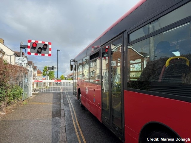
    Running more passenger trains through these crossings would increase how often barriers need to be lowered and the amount of time they would be closed for. This would have implications for safety, traffic flows, and how local streets operate. For this reason, the future of the level crossings needs to be considered alongside the development of the WLO. 

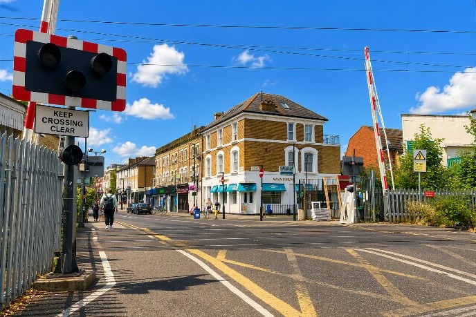
    A photograph of the level crossing at Churchfield RoadUnder current railway operating rules, the level crossing barriers - which are already lowered for around 40% to 50% of the time during the day - would be closed for longer periods and the safety risks of continuing to operate the crossings would increase. For example, there could be an increase in risk taking behaviour from drivers and pedestrians frustrated by a long wait to cross the railway. When WLO services are added, the barriers would be lowered for up to 75% of the time for periods as long as 11 minutes at a time. While technology improvements are being explored which could result in barrier down times not increasing this much, based on the current rules closure of the level crossings to road traffic would be required.
    Regardless of the WLO, closing level crossings where reasonably practicable to separate the public from the railway is a national Network Rail policy for safety reasons and a programme of level crossing closures is ongoing nationwide.

    We are looking at where displaced traffic might go and how we would minimise the impact on local residents, businesses, pedestrians and cyclists if the level crossings have to close. We are also assessing whether there are safe and practical ways for any of the crossings to remain open. For example, reducing vehicular traffic using the crossings to local residents only, while also providing alternative ways for pedestrians to cross the railway, could offset the increased safety risks resulting from longer barrier down times.


    Potential impacts of level crossing closures


    If the level crossings have to close, this would mean that people travelling on foot, by cycle or in a vehicle would need to find alternative ways to cross the railway line. For vehicles, this would involve having to cross the railway at an alternative location, while bridges or other options for pedestrians and cyclists to cross the railway would be available at the crossing closure points or nearby.
    When a level crossing is closed, traffic levels would reduce in the immediate area but may increase on some surrounding roads. Where traffic reduces, there will be opportunities to repurpose street space to improve the local environment and prioritise people with, for example, wider pavements, cycling improvements, pedestrianisation, and planting. Where traffic increases, measures could be introduced to control vehicle speeds or restrict vehicle access.


    New access arrangements


    The level crossings all have residential properties and other facilities such as shops and schools nearby. If a decision were taken that the level crossings would need to close, care will be taken to ensure pedestrians and cyclists can still safely cross the railway.

    We would make sure that: 

    • Accessible, convenient and attractive routes are still available for pedestrians and cyclists to cross the railway safely

    • Displaced traffic can continue to move around the area without causing problems. We need to do further work to fully understand traffic impacts and this will involve ongoing engagement with local communities and further formal consultation in the future


    The alternative pedestrian and cyclist crossing solutions we are exploring include:

    • Footbridges at all three crossings which could allow many users to cross without a long detour. These structures would need to be high enough to clear the railway and include either lifts or ramps to be accessible for all

    • The subway that already exists at Acton Central that could also offer step-free access


    To help inform our work we have:

    • Surveyed the number of users at each crossing - including people, cyclists and vehicles using each crossing

    • Started carrying out traffic modelling to determine the likely effects of any displaced traffic on nearby roads

    • Started discussions with the boroughs who manage these local road networks to look at the impact of level crossing closures on other local roads 

    • Begun considering what improvements to the street environment could be introduced around any closure points for the benefit of the local areas

    We would like to hear from local people, businesses and other stakeholders about any concerns and insights which will help us develop our proposals. We also plan to start a programme of engagement with the local communities and business groups around the level crossings, informed by the results of this consultation, to help us identify the best solutions. We will consult on detailed proposals for any level crossing closures in a future WLO public consultation.

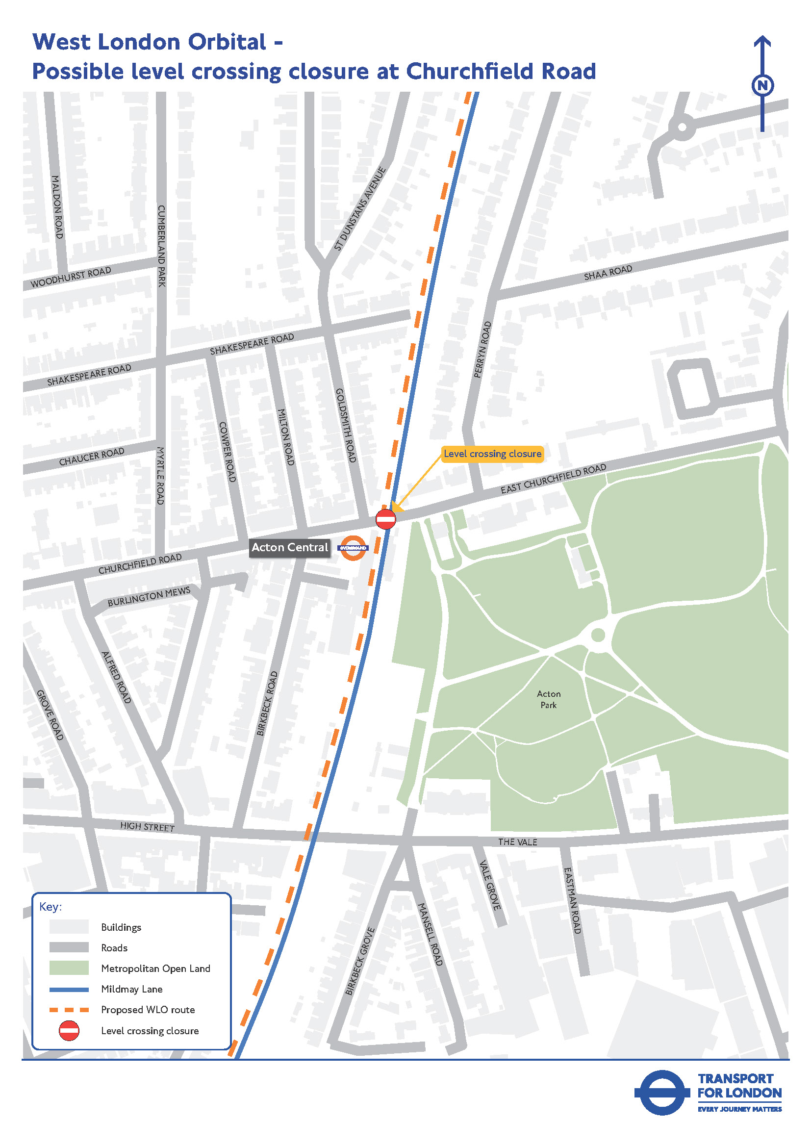
    Churchfield Road, Acton


    (Click map for larger version)


    The area around Churchfield Road is surrounded by residential properties and local businesses. It is situated within a conservation area, with the high street to the west and Acton Park to the east. The level crossing is adjacent to Acton Central station which is served by the Mildmay line.

    Closing the level crossing would have the potential to improve the local environment. We will be looking at options that could be considered to improve the street environment either side of the crossing.

    We are looking at options to maintain pedestrian and cyclist access across the railway if the crossing has to close.

    The solution could involve a new pedestrian/cycle bridge or make use of the existing station subway. We are considering several factors to help determine the most appropriate solution.


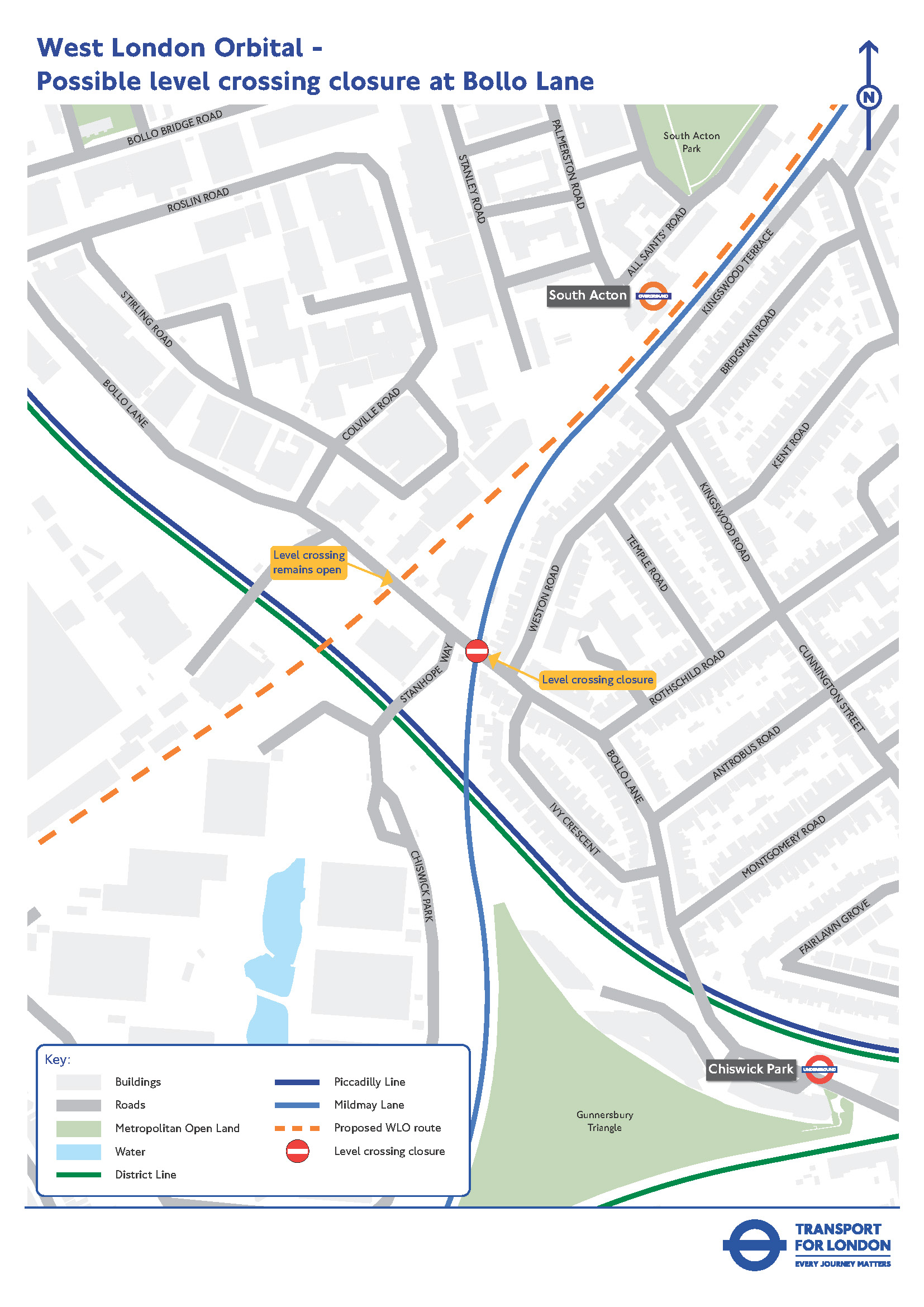
    Bollo Lane, South Acton


    Map showing location of possible level crossing closure on Bollo Lane(Click map for larger version)


    The area around Bollo Lane includes a mix of commercial and residential uses, with several developments planned to come forward in the coming years. 

    Bollo Lane has two level crossings in close proximity to each other. These are:

    • The ‘Kew line’ to the north, which would be used by WLO services, and is currently used only for freight trains

    • The ‘Richmond line’ to the south, which is currently used by both Mildmay line and freight services

    Due to the proximity of the crossings, if they were to remain open to traffic when WLO services begin to run, the barriers on both crossings would need to come down for a train passing on either line, to avoid the risk of vehicles queuing over the other crossing.

    Under current railway operating rules, at least one level crossing would therefore likely need to close, and through traffic would be displaced onto other routes. 

    It would be more practical to close the Richmond line level crossing on the Mildmay line, rather than the Kew Line (potential WLO) crossing because:

    • It would ensure access remains available to Chiswick Business Park and other properties between the two crossings, including for bus routes 440 and 70, so these bus routes would not need to be changed

    • The Kew line barriers for WLO trains would be able to remain open for traffic for around 60 per cent of the time since few other trains would be using this crossing. This is acceptable from a safety perspective considering that through traffic would no longer be using Bollo Lane

    • Closing the Richmond line crossing would also reduce the amount of traffic on Bollo Lane needing to queue while barriers are down at the Kew line crossing

    • Reducing through traffic on Bollo Lane would also support the redevelopment plans for the area which are to prioritise pedestrians where possible

    If this crossing has to close, the most likely option to maintain pedestrian and cycling access at this location could involve a new pedestrian/cycle bridge. We are also considering whether alternative pedestrian and cycle arrangements could be provided at nearby locations. This will be explored as part of the next design stage.


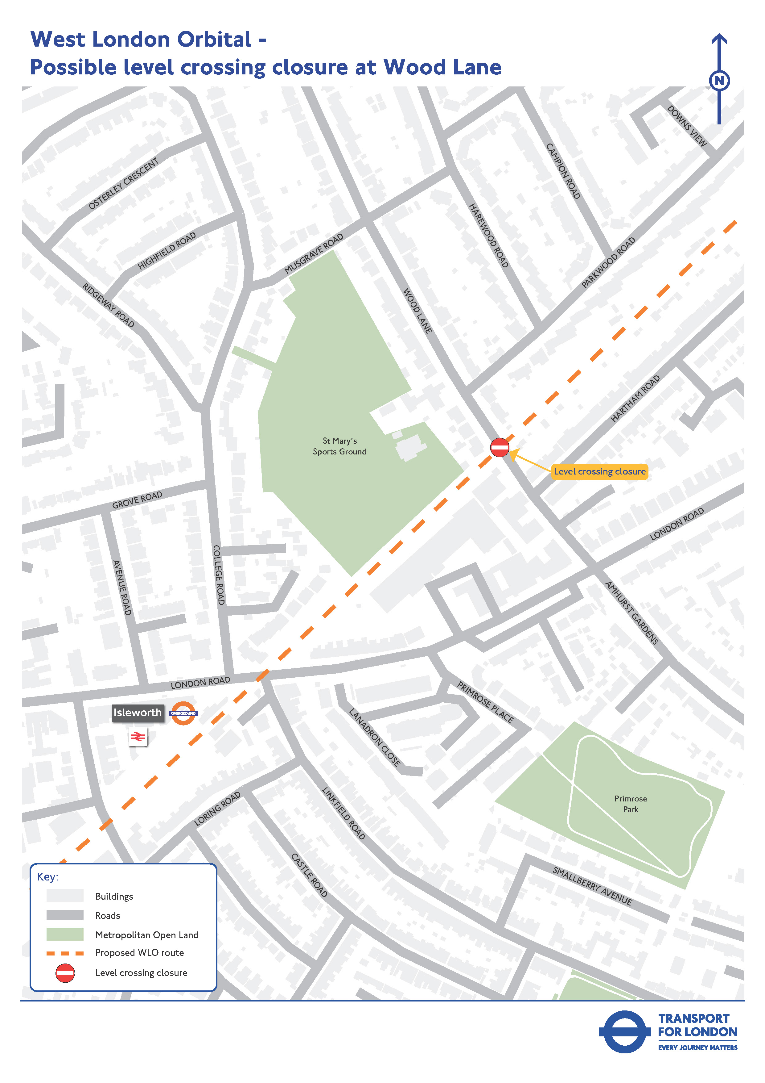
    Wood Lane, Isleworth


    Map showing location of possible level crossing closure at Wood Lane(Click map for larger version)


    The level crossing on Wood Lane, Isleworth, could also need to close. It is located in a mainly residential area, with some commercial properties, the Old Isleworthians Sports club and the Woodbridge Park Education Service Aspire Centre nearby.

    If the crossing has to close, we will look at any feasible options to maintain pedestrian and cycling access. We are considering several factors to help determine the most appropriate solution.

    We would also need to consult on changes to the H28 bus route, which currently uses this level crossing, if the crossing has to close. Any proposals for the H28 route would need to be consulted on in detail before changes could be made.


    Next steps

    We need to do more work on these proposals as part of the overall development of the WLO project. Construction of the WLO project would not start until the early 2030s, so there would be no impact on the level crossings in the next few years.

    These changes would have impacts, both positive and negative, for local residents and businesses and we would like to hear feedback to help inform this work. Please complete our survey.


    Return to main page

  • Transport and Works Act Order (TWAO)

    Share Transport and Works Act Order (TWAO) on Facebook Share Transport and Works Act Order (TWAO) on X (formerly Twitter) Share Transport and Works Act Order (TWAO) on Linkedin Email Transport and Works Act Order (TWAO) link

    The purpose of this page is to explain about the Transport and Works Act Order (TWAO) process which would be used to obtain consent to build and operate the WLO.

    What is a Transport and Works Act order?

    A TWAO is a statutory instrument made by the Secretary of State under the Transport and Works Act 1992. A TWAO can authorise the construction, operation and maintenance of new transport infrastructure, such as the proposed WLO. It can authorise the stopping up or diversion of any highways and the closure of level crossings.

    A TWAO application could also provide compulsory powers for acquiring property interests and rights or for the use of land temporarily. A TWAO application could also be accompanied by a request to the Secretary of State for Transport to give a direction for deemed planning permission for the works to be authorised by a TWAO, meaning that planning permission could be granted by the government rather than the local planning authority.

    The TWAO application process

    A TWAO application is submitted to the Secretary of State for Transport and the procedure that follows allows any interested person to have their say before a decision is made.

    The TWAO application would include:

    • A draft of the proposed TWAO for the extension which would grant the required powers to construct and operate the WLO

    • Supporting plans and documents

    • A request for a direction as to deemed planning permission

    • An Environmental Statement which provides a description of the proposed scheme and how we propose to carry out the works and manage the construction process. It also sets out how the proposed scheme may affect the environment and how we propose to reduce those potential effects to an acceptable level

    • A non-technical summary of the environmental statement

    • A Funding Statement

    • Information about all land or interests in land to be acquired or used for the purposes of the TWAO

    After a TWAO is applied for there would be a statutory period where representations, comments or objections can be submitted to the Secretary of State for Transport.

    The Secretary of State for Transport would consider the TWAO application carefully and all representations made during the process and make decisions only after considering all the comments made – sometimes through a public inquiry.

    Land acquisition and compensation

    The land and property needed for the extension would be acquired either voluntarily or by compulsory purchase powers granted through a TWAO. WLO is mostly on existing railway land which we anticipate will significantly reduce the need to acquire land. Some land will still be needed but we will plan to keep this to a minimum. Owners and occupiers of land that may be compulsorily acquired or temporarily used for the purposes of our proposals may be entitled to claim compensation. Where possible we would seek to reach an agreement with any landowner potentially affected by any compulsory purchase powers in advance of the TWAO application for those powers.


    Return to main page

    The purpose of this page is to explain about the Transport and Works Act Order (TWAO) process which would be used to obtain consent to build and operate the WLO.

    What is a Transport and Works Act order?

    A TWAO is a statutory instrument made by the Secretary of State under the Transport and Works Act 1992. A TWAO can authorise the construction, operation and maintenance of new transport infrastructure, such as the proposed WLO. It can authorise the stopping up or diversion of any highways and the closure of level crossings.

    A TWAO application could also provide compulsory powers for acquiring property interests and rights or for the use of land temporarily. A TWAO application could also be accompanied by a request to the Secretary of State for Transport to give a direction for deemed planning permission for the works to be authorised by a TWAO, meaning that planning permission could be granted by the government rather than the local planning authority.

    The TWAO application process

    A TWAO application is submitted to the Secretary of State for Transport and the procedure that follows allows any interested person to have their say before a decision is made.

    The TWAO application would include:

    • A draft of the proposed TWAO for the extension which would grant the required powers to construct and operate the WLO

    • Supporting plans and documents

    • A request for a direction as to deemed planning permission

    • An Environmental Statement which provides a description of the proposed scheme and how we propose to carry out the works and manage the construction process. It also sets out how the proposed scheme may affect the environment and how we propose to reduce those potential effects to an acceptable level

    • A non-technical summary of the environmental statement

    • A Funding Statement

    • Information about all land or interests in land to be acquired or used for the purposes of the TWAO

    After a TWAO is applied for there would be a statutory period where representations, comments or objections can be submitted to the Secretary of State for Transport.

    The Secretary of State for Transport would consider the TWAO application carefully and all representations made during the process and make decisions only after considering all the comments made – sometimes through a public inquiry.

    Land acquisition and compensation

    The land and property needed for the extension would be acquired either voluntarily or by compulsory purchase powers granted through a TWAO. WLO is mostly on existing railway land which we anticipate will significantly reduce the need to acquire land. Some land will still be needed but we will plan to keep this to a minimum. Owners and occupiers of land that may be compulsorily acquired or temporarily used for the purposes of our proposals may be entitled to claim compensation. Where possible we would seek to reach an agreement with any landowner potentially affected by any compulsory purchase powers in advance of the TWAO application for those powers.


    Return to main page

Page last updated: 23 Sep 2026, 11:29 AM